Burnage night lights from space
Night Light of Burnage (England) from space (United Kingdom) Src. Average luminocity for 10x10km area is 98.0013% and for 50x50km: 38.1216%.
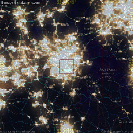
Analysis of Burnage night lights 2016
Square area 10x10 km:
 61.11%
90-99
32.54%80-89
3.31%70-79
2.78%60-69
0.26%50-59
0%40-49
0%30-39
0%20-29
0%10-19
0%0-9
0%Square area 50x50 km:
10.71%90-99
8.43%80-89
3.82%70-79
4.01%60-69
4.51%50-59
4.32%40-49
4.14%30-39
4.65%20-29
8.12%10-19
11.62%0-9
35.68%Clear (daylight) street map image can be seen on geolist.org.
Map coordinates:
53° 50' 58.2" North, 2° 54' 10.1" West
53° 25' 57.5" North, 2° 11' 58.8" West
53° 0' 42" North, 1° 29' 47.6" West
Some cities around Burnage sort by population:
• Manchester
5.9 km =3.7 mi,  335°
335°
• Stockport
3.8 km =2.4 mi,  132°
132°
• Denton
6 km =3.7 mi,  63°
63°
• Longsight
2.8 km =1.7 mi,  358°
358°
• Bredbury
5.8 km =3.6 mi,  107°
107°
• Didsbury
2.7 km =1.7 mi,  230°
230°
• Fallowfield
1.3 km =0.8 mi,  306°
306°
• Hulme
4.9 km =3 mi,  318°
318°
6691251 (p: 13,706)
Sources (retrieved 2019-11-25):
» Earth at Night: Flat Maps 2012, 2016