Berwick-Upon-Tweed night lights from space
Night Light of Berwick-Upon-Tweed (England) from space (United Kingdom) Src. Average luminocity for 10x10km area is 7.7572% and for 50x50km: 0.5559%.
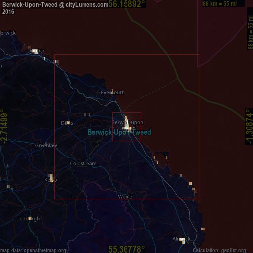
Analysis of Berwick-Upon-Tweed night lights 2016
Square area 10x10 km:
 1.32%
1.32%90-99
0.6%80-89
1.44%70-79
0.96%60-69
1.44%50-59
0.6%40-49
1.32%30-39
0%20-29
0.96%10-19
0.72%0-9
90.67%Square area 50x50 km:
0.06%90-99
0.05%80-89
0.1%70-79
0.04%60-69
0.12%50-59
0.06%40-49
0.11%30-39
0.06%20-29
0.12%10-19
0.13%0-9
99.16%Clear (daylight) street map image can be seen on geolist.org.
Map coordinates:
56° 9' 32.1" North, 2° 42' 54" West
55° 46' 7.2" North, 2° 0' 19.3" West
55° 22' 4" North, 1° 18' 31.5" West
Some cities around Berwick-Upon-Tweed sort by population:
• Galashiels
53.1 km =33 mi,  251°
251°
• Haddington
52.8 km =32.8 mi,  293°
293°
• Dunbar
40.9 km =25.4 mi,  309°
309°
• Alnwick
43.8 km =27.2 mi,  154°
154°
• North Berwick
55.1 km =34.2 mi, 305°
• Amble
55.2 km =34.3 mi, 151°
• Selkirk
57.8 km =35.9 mi,  244°
244°
• Kelso
32.9 km =20.4 mi,  234°
234°
2655819 (p: 13,265)
Sources (retrieved 2019-11-25):
» Earth at Night: Flat Maps 2012, 2016