Bedworth night lights from space
Night Light of Bedworth (England) from space (United Kingdom) Src. Average luminocity for 10x10km area is 49.9823% and for 50x50km: 28.2026%.
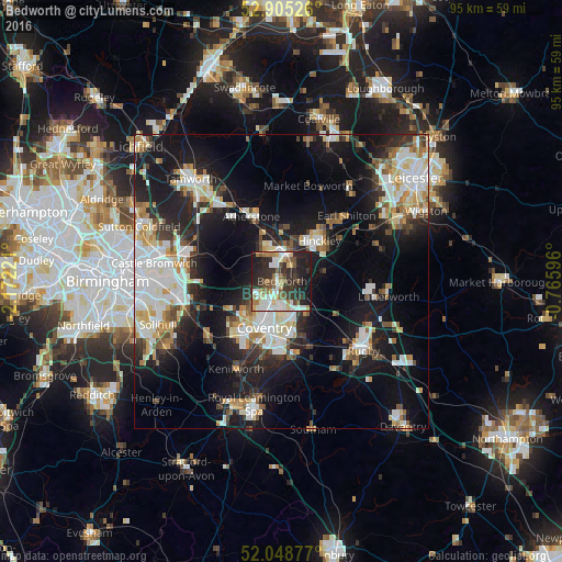

Analysis of Bedworth night lights 2016
Square area 10x10 km:
 9.97%
9.97%90-99
11.49%80-89
4.42%70-79
3.66%60-69
6.69%50-59
7.58%40-49
4.17%30-39
10.98%20-29
23.23%10-19
17.55%0-9
0.25%Square area 50x50 km:
5.9%90-99
6.53%80-89
2.69%70-79
2.86%60-69
2.9%50-59
2.62%40-49
2.72%30-39
3.27%20-29
7.67%10-19
19.44%0-9
43.4%Clear (daylight) street map image can be seen on geolist.org.
Map coordinates:
52° 54' 18.9" North, 2° 10' 20" West
52° 28' 44.8" North, 1° 28' 8.7" West
52° 2' 55.6" North, 0° 45' 57.5" West
Some cities around Bedworth sort by population:
• Coventry
8.6 km =5.3 mi,  199°
199°
• Nuneaton
4.9 km =3 mi,  3°
3°
• Hinckley
9.2 km =5.7 mi,  43°
43°
• Earl Shilton
15 km =9.3 mi, 43°
• Hartshill
8.5 km =5.3 mi,  334°
334°
• Atherstone
11.9 km =7.4 mi, 333°
• Attleborough
3.9 km =2.4 mi,  14°
14°
• Brandon
11.5 km =7.1 mi,  155°
155°
2656031 (p: 29,981)
Sources (retrieved 2019-11-25):
» Earth at Night: Flat Maps 2012, 2016