Armthorpe night lights from space
Night Light of Armthorpe (England) from space (United Kingdom) Src. Average luminocity for 10x10km area is 49.0926% and for 50x50km: 23.4993%.
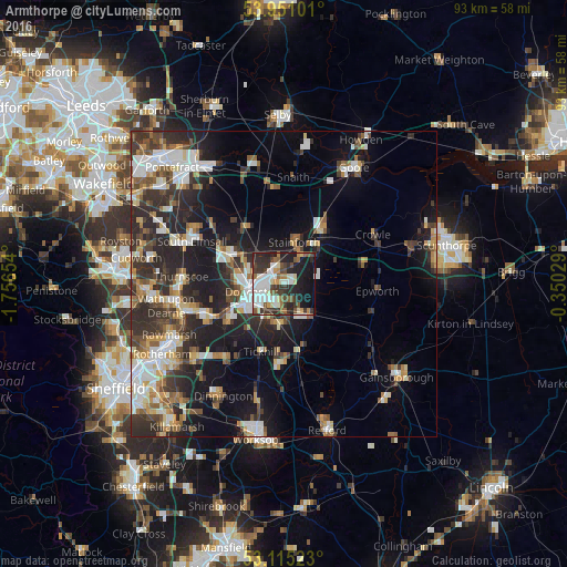
Analysis of Armthorpe night lights 2016
Square area 10x10 km:
 10.45%
90-99
11.9%80-89
4.89%70-79
3.57%60-69
4.23%50-59
7.28%40-49
5.16%30-39
12.3%20-29
16.27%10-19
21.43%0-9
2.51%Square area 50x50 km:
4.01%90-99
4.18%80-89
2.31%70-79
2.47%60-69
2.48%50-59
3.11%40-49
3.09%30-39
4.77%20-29
8.96%10-19
13.02%0-9
51.61%Clear (daylight) street map image can be seen on geolist.org.
Map coordinates:
53° 57' 3.6" North, 1° 45' 23.5" West
53° 32' 6.6" North, 1° 3' 12.3" West
53° 6' 54.8" North, 0° 21' 1" West
Some cities around Armthorpe sort by population:
• Doncaster
5.3 km =3.3 mi,  255°
255°
• Bentley
6.4 km =4 mi,  268°
268°
• Adwick le Street
9.5 km =5.9 mi,  294°
294°
• Thorne
10.3 km =6.4 mi,  35°
35°
• Kirk Sandall
3.2 km =2 mi,  341°
341°
• Carcroft
9.7 km =6 mi,  303°
303°
• Stainforth
7.3 km =4.5 mi,  10°
10°
• Askern
11.1 km =6.9 mi,  324°
324°
2657051 (p: 12,911)
Sources (retrieved 2019-11-25):
» Earth at Night: Flat Maps 2012, 2016