Appley Bridge night lights from space
Night Light of Appley Bridge (England) from space (United Kingdom) Src. Average luminocity for 10x10km area is 44% and for 50x50km: 45.5105%.
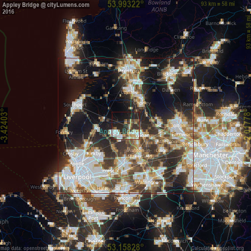
Analysis of Appley Bridge night lights 2016
Square area 10x10 km:
 7.7%
7.7%90-99
10.1%80-89
5.3%70-79
4.42%60-69
4.29%50-59
4.17%40-49
5.68%30-39
9.47%20-29
18.43%10-19
19.95%0-9
10.48%Square area 50x50 km:
10.63%90-99
10.06%80-89
4.38%70-79
4.72%60-69
5.73%50-59
5.2%40-49
6.93%30-39
7.1%20-29
11.03%10-19
16.98%0-9
17.24%Clear (daylight) street map image can be seen on geolist.org.
Map coordinates:
53° 59' 35.6" North, 3° 25' 26.5" West
53° 34' 40.1" North, 2° 43' 15.2" West
53° 9' 29.8" North, 2° 1' 4" West
Some cities around Appley Bridge sort by population:
• Wigan
6.8 km =4.2 mi,  124°
124°
• Skelmersdale
4.6 km =2.9 mi,  228°
228°
• Ince-in-Makerfield
8.5 km =5.3 mi,  125°
125°
• Coppull
6.7 km =4.2 mi,  37°
37°
• Burscough
8.1 km =5 mi,  284°
284°
• Adlington
8.5 km =5.3 mi,  62°
62°
• Billinge
8.9 km =5.5 mi,  174°
174°
• Shevington
1.9 km =1.2 mi,  108°
108°
2657224 (p: 5,270)
Sources (retrieved 2019-11-25):
» Earth at Night: Flat Maps 2012, 2016