Billinge night lights from space
Night Light of Billinge (England) from space (United Kingdom) Src. Average luminocity for 10x10km area is 63.5701% and for 50x50km: 45.7857%.
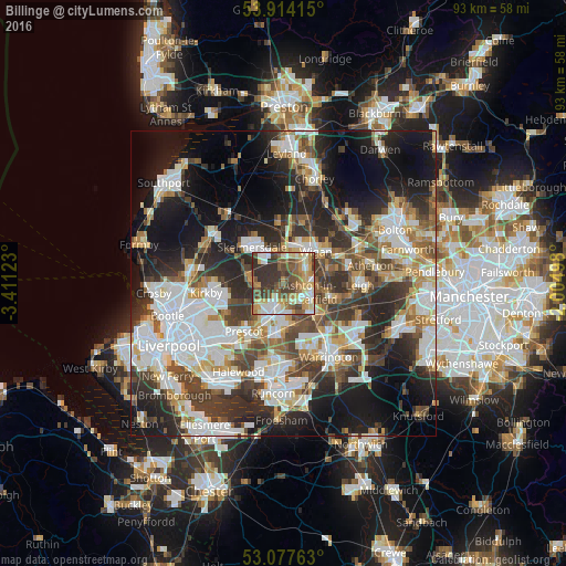
Analysis of Billinge night lights 2016
Square area 10x10 km:
 10.05%
90-99
10.98%80-89
11.77%70-79
10.19%60-69
7.67%50-59
13.89%40-49
12.43%30-39
15.48%20-29
7.54%10-19
0%0-9
0%Square area 50x50 km:
10.96%90-99
10.18%80-89
4.3%70-79
4.35%60-69
5.29%50-59
5.07%40-49
6.88%30-39
8.07%20-29
11.99%10-19
17.62%0-9
15.28%Clear (daylight) street map image can be seen on geolist.org.
Map coordinates:
53° 54' 50.9" North, 3° 24' 40.4" West
53° 29' 52.6" North, 2° 42' 29.2" West
53° 4' 39.5" North, 2° 0' 17.9" West
Some cities around Billinge sort by population:
• Wigan
6.9 km =4.3 mi,  43°
43°
• St Helens
5.6 km =3.5 mi,  197°
197°
• Skelmersdale
7.2 km =4.5 mi,  323°
323°
• Ashton in Makerfield
4.2 km =2.6 mi,  112°
112°
• Haydock
3.8 km =2.4 mi,  152°
152°
• Ince-in-Makerfield
7.2 km =4.5 mi,  56°
56°
• Abram
7.7 km =4.8 mi,  81°
81°
• Rainford
5.3 km =3.3 mi,  275°
275°
2655666 (p: 5,896)
Sources (retrieved 2019-11-25):
» Earth at Night: Flat Maps 2012, 2016