Ushaw Moor night lights from space
Night Light of Ushaw Moor (England) from space (United Kingdom) Src. Average luminocity for 10x10km area is 21.3659% and for 50x50km: 23.3496%.
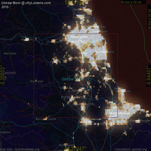
Analysis of Ushaw Moor night lights 2016
Square area 10x10 km:
 1.88%
1.88%90-99
2.01%80-89
1.88%70-79
3.63%60-69
5.01%50-59
3.13%40-49
3.01%30-39
3.13%20-29
7.39%10-19
18.8%0-9
50.13%Square area 50x50 km:
6.92%90-99
4.87%80-89
1.8%70-79
2.01%60-69
2.21%50-59
2.09%40-49
2.17%30-39
3.57%20-29
5.58%10-19
11.38%0-9
57.4%Clear (daylight) street map image can be seen on geolist.org.
Map coordinates:
55° 10' 53.5" North, 2° 21' 1.2" West
54° 46' 40.9" North, 1° 38' 49.9" West
54° 22' 13.7" North, 0° 56' 38.7" West
Some cities around Ushaw Moor sort by population:
• Durham
4.6 km =2.9 mi,  91°
91°
• Chester-le-Street
10.1 km =6.3 mi,  27°
27°
• Stanley
10.5 km =6.5 mi,  341°
341°
• Spennymoor
9.3 km =5.8 mi,  161°
161°
• Brandon
3.7 km =2.3 mi,  147°
147°
• Crook
9.8 km =6.1 mi,  222°
222°
• Sacriston
4.7 km =2.9 mi,  18°
18°
• Willington
7.6 km =4.7 mi,  206°
206°
2635054 (p: 7,368)
Sources (retrieved 2019-11-25):
» Earth at Night: Flat Maps 2012, 2016