Vesoul night lights from space
Night Light of Vesoul (Bourgogne-Franche-Comté) from space (France) Src. Average luminocity for 10x10km area is 29.6057% and for 50x50km: 2.4327%.
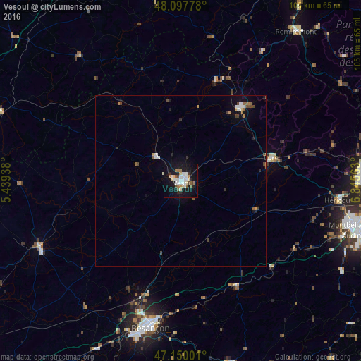
Analysis of Vesoul night lights 2016
Square area 10x10 km:
 5.95%
5.95%90-99
7.44%80-89
2.83%70-79
1.49%60-69
3.27%50-59
2.83%40-49
2.68%30-39
0.45%20-29
4.17%10-19
37.5%0-9
31.4%Square area 50x50 km:
0.38%90-99
0.48%80-89
0.15%70-79
0.19%60-69
0.27%50-59
0.29%40-49
0.35%30-39
0.2%20-29
0.31%10-19
2%0-9
95.39%Clear (daylight) street map image can be seen on geolist.org.
Map coordinates:
48° 5' 52" North, 5° 26' 21.8" East
47° 37' 33.7" North, 6° 8' 33" East
47° 9' 0" North, 6° 50' 44.3" East
Some cities around Vesoul sort by population:
• Besançon
43 km =26.7 mi,  192°
192°
• Montbéliard
50.9 km =31.6 mi,  104°
104°
• Héricourt
46.8 km =29.1 mi, 97°
• Lure
27.3 km =17 mi,  76°
76°
• Luxeuil-les-Bains
27 km =16.8 mi,  38°
38°
• Gray
45.9 km =28.5 mi,  244°
244°
• Bethoncourt
50.7 km =31.5 mi, 101°
• Baume-les-Dames
34.5 km =21.4 mi,  151°
151°
2969562 (p: 19,892)
Sources (retrieved 2019-11-25):
» Earth at Night: Flat Maps 2012, 2016