Héricourt night lights from space
Night Light of Héricourt (Bourgogne-Franche-Comté) from space (France) Src. Average luminocity for 10x10km area is 26.2116% and for 50x50km: 10.7097%.
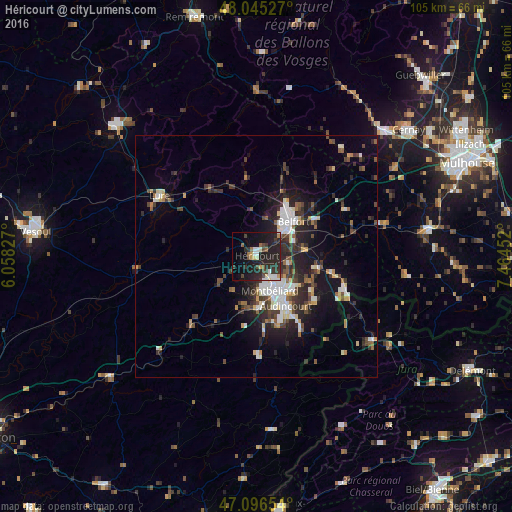
Analysis of Héricourt night lights 2016
Square area 10x10 km:
 3.69%
3.69%90-99
3.69%80-89
1.42%70-79
2.84%60-69
1.85%50-59
1.56%40-49
4.83%30-39
5.26%20-29
20.74%10-19
24.15%0-9
29.97%Square area 50x50 km:
1.63%90-99
1.93%80-89
0.95%70-79
0.71%60-69
0.8%50-59
1.23%40-49
1.89%30-39
2.15%20-29
4.42%10-19
7.07%0-9
77.23%Clear (daylight) street map image can be seen on geolist.org.
Map coordinates:
48° 2' 43" North, 6° 3' 29.8" East
47° 34' 23" North, 6° 45' 41" East
47° 5' 47.5" North, 7° 27' 52.3" East
Some cities around Héricourt sort by population:
• Belfort
10.4 km =6.5 mi,  42°
42°
• Montbéliard
7.6 km =4.7 mi,  158°
158°
• Audincourt
12.1 km =7.5 mi,  145°
145°
• Valentigney
13.2 km =8.2 mi, 156°
• Bethoncourt
5.3 km =3.3 mi,  142°
142°
• Mandeure
14.2 km =8.8 mi,  165°
165°
• Grand-Charmont
7.1 km =4.4 mi, 136°
• Valdoie
12.4 km =7.7 mi,  29°
29°
3013456 (p: 10,985)
Sources (retrieved 2019-11-25):
» Earth at Night: Flat Maps 2012, 2016