Aulnoy-lez-Valenciennes night lights from space
Night Light of Aulnoy-lez-Valenciennes (Hauts-de-France) from space (France) Src. Average luminocity for 10x10km area is 61.2185% and for 50x50km: 26.0142%.
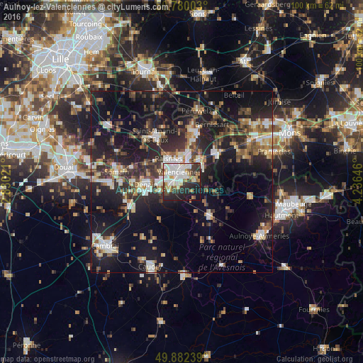
Analysis of Aulnoy-lez-Valenciennes night lights 2016
Square area 10x10 km:
 19.47%
90-99
15.69%80-89
7.56%70-79
5.18%60-69
3.78%50-59
4.48%40-49
4.9%30-39
9.24%20-29
17.09%10-19
12.32%0-9
0.28%Square area 50x50 km:
3.26%90-99
4.27%80-89
2.54%70-79
2.36%60-69
3.21%50-59
3.55%40-49
4.12%30-39
4.78%20-29
10.74%10-19
22.78%0-9
38.38%Clear (daylight) street map image can be seen on geolist.org.
Map coordinates:
50° 46' 48.1" North, 2° 49' 48.8" East
50° 19' 60" North, 3° 31' 60" East
49° 52' 56.6" North, 4° 14' 11.3" East
Some cities around Aulnoy-lez-Valenciennes sort by population:
• Valenciennes
2.9 km =1.8 mi,  348°
348°
• Anzin
4.8 km =3 mi,  334°
334°
• Raismes
6.6 km =4.1 mi, 327°
• Marly
1.8 km =1.1 mi,  40°
40°
• Saint-Saulve
4.5 km =2.8 mi,  20°
20°
• Beuvrages
6.3 km =3.9 mi, 333°
• Trith-Saint-Léger
4 km =2.5 mi,  242°
242°
• Petite-Forêt
5.1 km =3.2 mi,  316°
316°
3036133 (p: 8,172)
Sources (retrieved 2019-11-25):
» Earth at Night: Flat Maps 2012, 2016