Val-de-Reuil night lights from space
Night Light of Val-de-Reuil (Normandy) from space (France) Src. Average luminocity for 10x10km area is 31.5775% and for 50x50km: 15.681%.
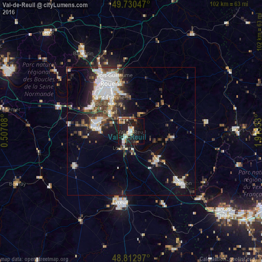
Analysis of Val-de-Reuil night lights 2016
Square area 10x10 km:
 4.95%
4.95%90-99
6.95%80-89
2.27%70-79
5.75%60-69
2.94%50-59
1.47%40-49
1.6%30-39
2.01%20-29
15.91%10-19
32.75%0-9
23.4%Square area 50x50 km:
3.64%90-99
3.3%80-89
0.99%70-79
1.15%60-69
1.3%50-59
1.63%40-49
2.28%30-39
2.75%20-29
4.19%10-19
9.25%0-9
69.53%Clear (daylight) street map image can be seen on geolist.org.
Map coordinates:
49° 43' 49.7" North, 0° 30' 25.5" East
49° 16' 25.9" North, 1° 12' 36.8" East
48° 48' 46.7" North, 1° 54' 48" East
Some cities around Val-de-Reuil sort by population:
• Saint-Étienne-du-Rouvray
13.9 km =8.6 mi,  326°
326°
• Louviers
7.1 km =4.4 mi,  206°
206°
• Oissel
10.7 km =6.6 mi,  308°
308°
• Caudebec-lès-Elbeuf
13.7 km =8.5 mi,  273°
273°
• Les Andelys
15 km =9.3 mi,  102°
102°
• Saint-Pierre-lès-Elbeuf
12.1 km =7.5 mi, 272°
• Saint-Aubin-lès-Elbeuf
14.9 km =9.3 mi,  282°
282°
• Cléon
13.8 km =8.6 mi,  288°
288°
6619659 (p: 13,824)
Sources (retrieved 2019-11-25):
» Earth at Night: Flat Maps 2012, 2016