Saint-Pierre-lès-Elbeuf night lights from space
Night Light of Saint-Pierre-lès-Elbeuf (Normandy) from space (France) Src. Average luminocity for 10x10km area is 40.9773% and for 50x50km: 15.4773%.
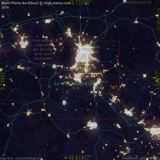
Analysis of Saint-Pierre-lès-Elbeuf night lights 2016
Square area 10x10 km:
 9.76%
9.76%90-99
9.09%80-89
2.14%70-79
2.41%60-69
4.81%50-59
4.55%40-49
5.75%30-39
6.28%20-29
17.65%10-19
24.73%0-9
12.83%Square area 50x50 km:
3.53%90-99
3.12%80-89
1.05%70-79
1.21%60-69
1.39%50-59
1.79%40-49
2.2%30-39
2.71%20-29
4.26%10-19
7.85%0-9
70.87%Clear (daylight) street map image can be seen on geolist.org.
Map coordinates:
49° 44' 8.1" North, 0° 20' 23.7" East
49° 16' 44.4" North, 1° 2' 35" East
48° 49' 5.4" North, 1° 44' 46.2" East
Some cities around Saint-Pierre-lès-Elbeuf sort by population:
• Louviers
11.3 km =7 mi,  127°
127°
• Elbeuf
3 km =1.9 mi,  286°
286°
• Val-de-Reuil
12.1 km =7.5 mi,  92°
92°
• Oissel
7.1 km =4.4 mi,  31°
31°
• Caudebec-lès-Elbeuf
1.5 km =0.9 mi,  277°
277°
• Grand-Couronne
8.9 km =5.5 mi,  342°
342°
• Petit-Couronne
11.8 km =7.3 mi,  350°
350°
• Cléon
3.8 km =2.4 mi, 345°
2977428 (p: 8,602)
Sources (retrieved 2019-11-25):
» Earth at Night: Flat Maps 2012, 2016