Oissel night lights from space
Night Light of Oissel (Normandy) from space (France) Src. Average luminocity for 10x10km area is 50.5468% and for 50x50km: 16.5282%.
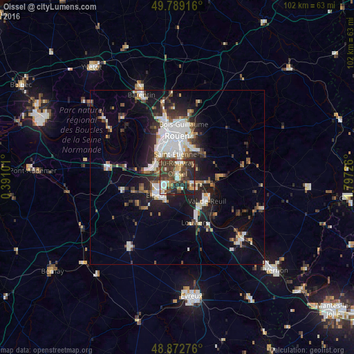
Analysis of Oissel night lights 2016
Square area 10x10 km:
 6.55%
6.55%90-99
9.09%80-89
2.94%70-79
5.75%60-69
6.15%50-59
6.95%40-49
21.12%30-39
18.32%20-29
16.84%10-19
6.28%0-9
0%Square area 50x50 km:
3.64%90-99
3.25%80-89
1.01%70-79
1.37%60-69
1.49%50-59
1.95%40-49
2.43%30-39
3%20-29
4.57%10-19
9.32%0-9
67.97%Clear (daylight) street map image can be seen on geolist.org.
Map coordinates:
49° 47' 21" North, 0° 23' 27.6" East
49° 19' 59.1" North, 1° 5' 38.9" East
48° 52' 21.9" North, 1° 47' 50.1" East
Some cities around Oissel sort by population:
• Saint-Étienne-du-Rouvray
5 km =3.1 mi,  8°
8°
• Le Grand-Quevilly
8.3 km =5.2 mi,  335°
335°
• Caudebec-lès-Elbeuf
7.8 km =4.8 mi,  221°
221°
• Grand-Couronne
6.8 km =4.2 mi,  291°
291°
• Petit-Couronne
7.9 km =4.9 mi,  314°
314°
• Saint-Pierre-lès-Elbeuf
7.1 km =4.4 mi,  211°
211°
• Saint-Aubin-lès-Elbeuf
6.9 km =4.3 mi,  241°
241°
• Cléon
5.2 km =3.2 mi, 243°
2989646 (p: 11,495)
Sources (retrieved 2019-11-25):
» Earth at Night: Flat Maps 2012, 2016