Vaison-la-Romaine night lights from space
Night Light of Vaison-la-Romaine (Provence-Alpes-Côte d'Azur) from space (France) Src. Average luminocity for 10x10km area is 13.9288% and for 50x50km: 9.0709%.
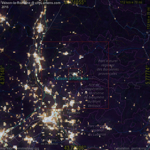
Analysis of Vaison-la-Romaine night lights 2016
Square area 10x10 km:
 0.76%
0.76%90-99
3.48%80-89
1.52%70-79
1.97%60-69
1.36%50-59
0.45%40-49
1.67%30-39
0.91%20-29
2.27%10-19
1.06%0-9
84.55%Square area 50x50 km:
0.78%90-99
1.56%80-89
1.13%70-79
1.08%60-69
0.98%50-59
0.78%40-49
0.86%30-39
0.82%20-29
2.25%10-19
10.17%0-9
79.59%Clear (daylight) street map image can be seen on geolist.org.
Map coordinates:
44° 44' 26" North, 4° 22' 17.4" East
44° 14' 20.3" North, 5° 4' 28.6" East
43° 43' 59" North, 5° 46' 39.9" East
Some cities around Vaison-la-Romaine sort by population:
• Orange
23.9 km =14.9 mi,  241°
241°
• Carpentras
20.6 km =12.8 mi,  185°
185°
• Monteux
23.4 km =14.5 mi,  195°
195°
• Valréas
17.5 km =10.9 mi,  337°
337°
• Nyons
14.5 km =9 mi,  21°
21°
• Sarrians
19.2 km =11.9 mi,  205°
205°
• Courthézon
22.7 km =14.1 mi,  222°
222°
• Mazan
20.7 km =12.9 mi,  168°
168°
2971154 (p: 6,207)
Sources (retrieved 2019-11-25):
» Earth at Night: Flat Maps 2012, 2016