Courthézon night lights from space
Night Light of Courthézon (Provence-Alpes-Côte d'Azur) from space (France) Src. Average luminocity for 10x10km area is 27.0167% and for 50x50km: 21.5599%.
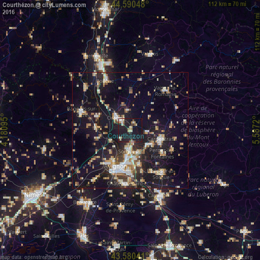
Analysis of Courthézon night lights 2016
Square area 10x10 km:
 2.12%
2.12%90-99
4.55%80-89
4.55%70-79
1.82%60-69
3.03%50-59
2.42%40-49
1.82%30-39
1.82%20-29
5.76%10-19
58.79%0-9
13.33%Square area 50x50 km:
2.36%90-99
3.81%80-89
2.38%70-79
2.66%60-69
2.69%50-59
2.35%40-49
2.36%30-39
2.56%20-29
5.61%10-19
25.48%0-9
47.75%Clear (daylight) street map image can be seen on geolist.org.
Map coordinates:
44° 35' 25.7" North, 4° 10' 51.4" East
44° 5' 15.4" North, 4° 53' 2.7" East
43° 34' 49.5" North, 5° 35' 13.9" East
Some cities around Courthézon sort by population:
• Orange
8.1 km =5 mi,  313°
313°
• Sorgues
8.6 km =5.3 mi,  185°
185°
• Monteux
10.6 km =6.6 mi,  122°
122°
• Vedène
12.4 km =7.7 mi,  172°
172°
• Entraigues-sur-la-Sorgue
10 km =6.2 mi,  160°
160°
• Sarrians
7 km =4.3 mi,  94°
94°
• Roquemaure
9.5 km =5.9 mi,  243°
243°
• Bédarrides
5.4 km =3.4 mi, 167°
3022897 (p: 5,723)
Sources (retrieved 2019-11-25):
» Earth at Night: Flat Maps 2012, 2016