Monteux night lights from space
Night Light of Monteux (Provence-Alpes-Côte d'Azur) from space (France) Src. Average luminocity for 10x10km area is 37.5524% and for 50x50km: 19.9381%.
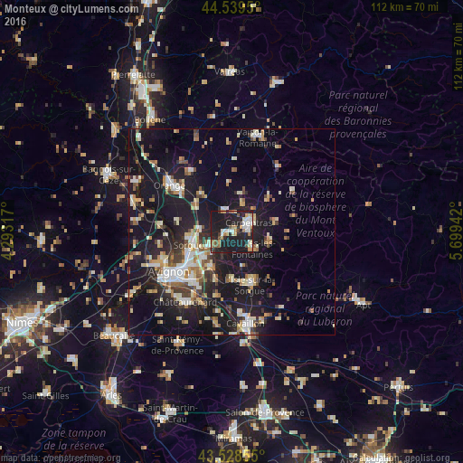
Analysis of Monteux night lights 2016
Square area 10x10 km:
 6.98%
6.98%90-99
6.83%80-89
2.06%70-79
5.87%60-69
4.92%50-59
2.54%40-49
3.65%30-39
2.22%20-29
16.83%10-19
47.78%0-9
0.32%Square area 50x50 km:
2.38%90-99
3.72%80-89
2.47%70-79
2.24%60-69
2.26%50-59
2.19%40-49
1.96%30-39
2.44%20-29
5.26%10-19
24.5%0-9
50.57%Clear (daylight) street map image can be seen on geolist.org.
Map coordinates:
44° 32' 22.2" North, 4° 17' 35.4" East
44° 2' 10.2" North, 4° 59' 46.7" East
43° 31' 42.8" North, 5° 41' 57.9" East
Some cities around Monteux sort by population:
• Carpentras
4.6 km =2.9 mi,  63°
63°
• Sorgues
10.2 km =6.3 mi,  253°
253°
• Pernes-les-Fontaines
6.6 km =4.1 mi,  130°
130°
• Vedène
9.8 km =6.1 mi,  228°
228°
• Entraigues-sur-la-Sorgue
6.7 km =4.2 mi,  236°
236°
• Sarrians
5.6 km =3.5 mi,  338°
338°
• Courthézon
10.6 km =6.6 mi,  302°
302°
• Bédarrides
7.9 km =4.9 mi,  273°
273°
2992638 (p: 10,828)
Sources (retrieved 2019-11-25):
» Earth at Night: Flat Maps 2012, 2016