Valréas night lights from space
Night Light of Valréas (Provence-Alpes-Côte d'Azur) from space (France) Src. Average luminocity for 10x10km area is 11.146% and for 50x50km: 9.1214%.
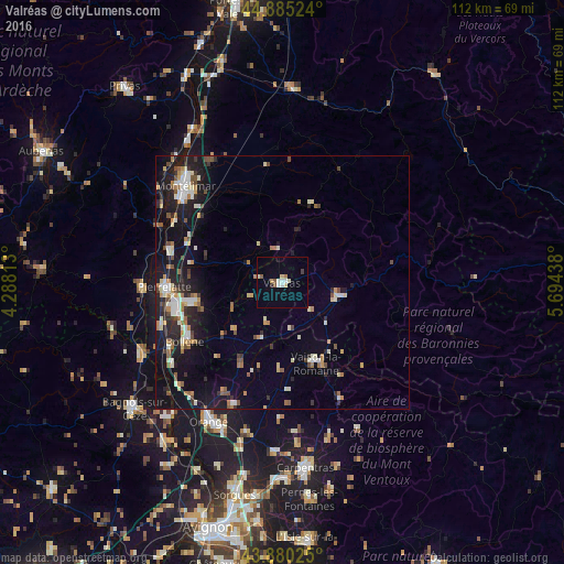
Analysis of Valréas night lights 2016
Square area 10x10 km:
 1.27%
1.27%90-99
2.38%80-89
2.06%70-79
0.63%60-69
0.63%50-59
1.27%40-49
0.63%30-39
0.63%20-29
0.63%10-19
0.16%0-9
89.68%Square area 50x50 km:
0.9%90-99
1.76%80-89
0.93%70-79
1%60-69
1.14%50-59
0.99%40-49
1.05%30-39
0.85%20-29
2.55%10-19
7.97%0-9
80.87%Clear (daylight) street map image can be seen on geolist.org.
Map coordinates:
44° 53' 6.9" North, 4° 17' 17.3" East
44° 23' 5.6" North, 4° 59' 28.5" East
43° 52' 48.9" North, 5° 41' 39.8" East
Some cities around Valréas sort by population:
• Montélimar
26.6 km =16.5 mi,  315°
315°
• Bollène
22.5 km =14 mi,  239°
239°
• Pierrelatte
22.9 km =14.2 mi,  267°
267°
• Le Teil
30.3 km =18.8 mi,  306°
306°
• Bourg-Saint-Andéol
27.6 km =17.1 mi, 267°
• Saint-Paul-Trois-Châteaux
18.6 km =11.6 mi,  256°
256°
• Nyons
12.2 km =7.6 mi,  102°
102°
• Vaison-la-Romaine
17.5 km =10.9 mi,  157°
157°
2970838 (p: 10,211)
Sources (retrieved 2019-11-25):
» Earth at Night: Flat Maps 2012, 2016