Sarrians night lights from space
Night Light of Sarrians (Provence-Alpes-Côte d'Azur) from space (France) Src. Average luminocity for 10x10km area is 21.4515% and for 50x50km: 19.6659%.
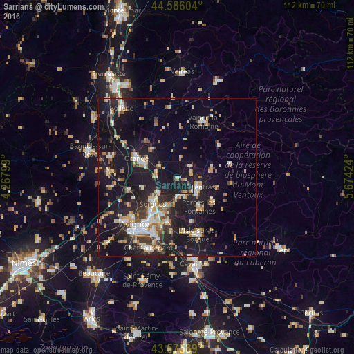
Analysis of Sarrians night lights 2016
Square area 10x10 km:
 1.36%
1.36%90-99
2.58%80-89
2.88%70-79
1.97%60-69
1.82%50-59
1.97%40-49
1.36%30-39
1.52%20-29
8.94%10-19
44.55%0-9
31.06%Square area 50x50 km:
2.25%90-99
3.54%80-89
2.27%70-79
2.35%60-69
2.39%50-59
2.09%40-49
2.02%30-39
2.46%20-29
5.45%10-19
23.78%0-9
51.41%Clear (daylight) street map image can be seen on geolist.org.
Map coordinates:
44° 35' 9.7" North, 4° 16' 4.8" East
44° 4' 59.2" North, 4° 58' 16" East
43° 34' 33.2" North, 5° 40' 27.3" East
Some cities around Sarrians sort by population:
• Carpentras
6.9 km =4.3 mi,  116°
116°
• Sorgues
11.2 km =7 mi,  223°
223°
• Pernes-les-Fontaines
11.8 km =7.3 mi,  143°
143°
• Monteux
5.6 km =3.5 mi,  158°
158°
• Entraigues-sur-la-Sorgue
9.6 km =6 mi,  201°
201°
• Courthézon
7 km =4.3 mi,  274°
274°
• Mazan
12.8 km =8 mi,  103°
103°
• Bédarrides
7.5 km =4.7 mi,  230°
230°
2975953 (p: 5,817)
Sources (retrieved 2019-11-25):
» Earth at Night: Flat Maps 2012, 2016