Thaon-les-Vosges night lights from space
Night Light of Thaon-les-Vosges (Grand Est) from space (France) Src. Average luminocity for 10x10km area is 21.1667% and for 50x50km: 3.8959%.
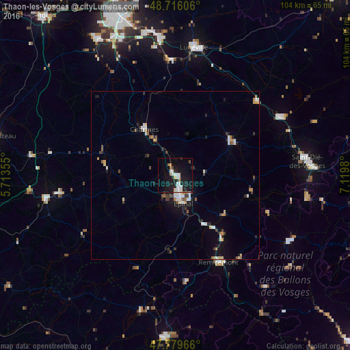
Analysis of Thaon-les-Vosges night lights 2016
Square area 10x10 km:
 5.06%
5.06%90-99
4.46%80-89
1.19%70-79
1.04%60-69
1.34%50-59
0.6%40-49
1.19%30-39
0.15%20-29
8.48%10-19
29.02%0-9
47.47%Square area 50x50 km:
0.59%90-99
0.65%80-89
0.32%70-79
0.45%60-69
0.38%50-59
0.36%40-49
0.4%30-39
0.5%20-29
0.89%10-19
2.62%0-9
92.84%Clear (daylight) street map image can be seen on geolist.org.
Map coordinates:
48° 42' 57.8" North, 5° 42' 48.8" East
48° 15' 0" North, 6° 25' 0" East
47° 46' 46.8" North, 7° 7' 11.3" East
Some cities around Thaon-les-Vosges sort by population:
• Épinal
7.9 km =4.9 mi,  160°
160°
• Lunéville
38.5 km =23.9 mi,  8°
8°
• Gérardmer
39.4 km =24.5 mi,  119°
119°
• Remiremont
28.8 km =17.9 mi,  153°
153°
• Golbey
6.1 km =3.8 mi, 163°
• Mirecourt
21.8 km =13.5 mi,  285°
285°
• Rambervillers
19.2 km =11.9 mi,  57°
57°
• Vittel
35.1 km =21.8 mi,  261°
261°
2973008 (p: 8,009)
Sources (retrieved 2019-11-25):
» Earth at Night: Flat Maps 2012, 2016