Mirecourt night lights from space
Night Light of Mirecourt (Grand Est) from space (France) Src. Average luminocity for 10x10km area is 4.6518% and for 50x50km: 3.3007%.
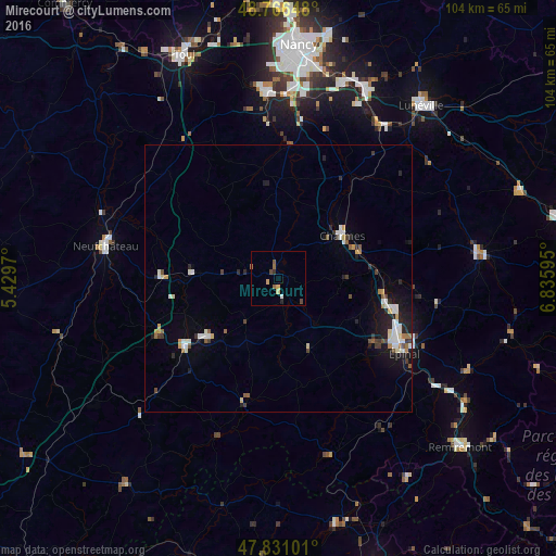
Analysis of Mirecourt night lights 2016
Square area 10x10 km:
 0%
0%90-99
0.6%80-89
0.6%70-79
1.19%60-69
0.74%50-59
1.34%40-49
1.19%30-39
0.6%20-29
0.15%10-19
0.45%0-9
93.15%Square area 50x50 km:
0.52%90-99
0.63%80-89
0.25%70-79
0.32%60-69
0.29%50-59
0.43%40-49
0.31%30-39
0.46%20-29
0.66%10-19
1.9%0-9
94.22%Clear (daylight) street map image can be seen on geolist.org.
Map coordinates:
48° 45' 59.3" North, 5° 25' 46.9" East
48° 18' 3.2" North, 6° 7' 58.2" East
47° 49' 51.6" North, 6° 50' 9.4" East
Some cities around Mirecourt sort by population:
• Épinal
27.1 km =16.8 mi,  118°
118°
• Golbey
25.5 km =15.8 mi, 116°
• Neufchâteau
32.9 km =20.4 mi,  280°
280°
• Thaon-les-Vosges
21.8 km =13.5 mi,  105°
105°
• Ludres
35.6 km =22.1 mi,  4°
4°
• Neuves-Maisons
35.3 km =21.9 mi,  356°
356°
• Rambervillers
37.5 km =23.3 mi,  82°
82°
• Vittel
17.6 km =10.9 mi,  230°
230°
2993728 (p: 6,998)
Sources (retrieved 2019-11-25):
» Earth at Night: Flat Maps 2012, 2016