Rambervillers night lights from space
Night Light of Rambervillers (Grand Est) from space (France) Src. Average luminocity for 10x10km area is 6.8054% and for 50x50km: 4.9375%.
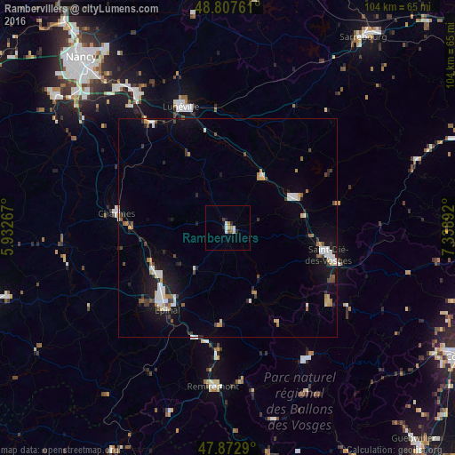
Analysis of Rambervillers night lights 2016
Square area 10x10 km:
 1.7%
1.7%90-99
1.14%80-89
0%70-79
1.56%60-69
0.28%50-59
0.85%40-49
0.14%30-39
0.57%20-29
2.27%10-19
0.14%0-9
91.34%Square area 50x50 km:
0.79%90-99
0.87%80-89
0.35%70-79
0.53%60-69
0.46%50-59
0.45%40-49
0.55%30-39
0.54%20-29
1.02%10-19
3.37%0-9
91.07%Clear (daylight) street map image can be seen on geolist.org.
Map coordinates:
48° 48' 27.4" North, 5° 55' 57.6" East
48° 20' 32.6" North, 6° 38' 8.9" East
47° 52' 22.4" North, 7° 20' 20.1" East
Some cities around Rambervillers sort by population:
• Épinal
22.3 km =13.9 mi,  217°
217°
• Saint-Dié-des-Vosges
24.1 km =15 mi,  105°
105°
• Lunéville
29.7 km =18.5 mi,  339°
339°
• Gérardmer
34.9 km =21.7 mi,  149°
149°
• Remiremont
36.3 km =22.6 mi,  185°
185°
• Dombasle-sur-Meurthe
37 km =23 mi,  326°
326°
• Golbey
21.7 km =13.5 mi, 222°
• Thaon-les-Vosges
19.2 km =11.9 mi,  237°
237°
2984516 (p: 6,182)
Sources (retrieved 2019-11-25):
» Earth at Night: Flat Maps 2012, 2016