Castelginest night lights from space
Night Light of Castelginest (Occitanie) from space (France) Src. Average luminocity for 10x10km area is 75.6424% and for 50x50km: 24.1965%.
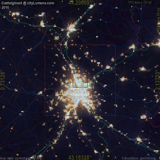
Analysis of Castelginest night lights 2016
Square area 10x10 km:
 19.24%
90-99
23.48%80-89
9.24%70-79
7.58%60-69
13.48%50-59
10.91%40-49
5.76%30-39
4.7%20-29
4.09%10-19
1.52%0-9
0%Square area 50x50 km:
4.99%90-99
5.24%80-89
2.72%70-79
2.38%60-69
3.04%50-59
3.33%40-49
3.48%30-39
3.2%20-29
5.36%10-19
8.07%0-9
58.19%Clear (daylight) street map image can be seen on geolist.org.
Map coordinates:
44° 12' 0.2" North, 0° 43' 52.6" East
43° 41' 37.8" North, 1° 26' 3.8" East
43° 10' 59.8" North, 2° 8' 15.1" East
Some cities around Castelginest sort by population:
• Toulouse
10 km =6.2 mi,  175°
175°
• Blagnac
7.5 km =4.7 mi,  205°
205°
• L'Union
5.4 km =3.4 mi,  133°
133°
• Saint-Jean
6.2 km =3.9 mi,  122°
122°
• Aucamville
2.7 km =1.7 mi,  190°
190°
• Beauzelle
5.6 km =3.5 mi,  238°
238°
• Launaguet
2.5 km =1.6 mi, 134°
• Saint-Alban
1.9 km =1.2 mi,  266°
266°
3028388 (p: 8,709)
Sources (retrieved 2019-11-25):
» Earth at Night: Flat Maps 2012, 2016