Aucamville night lights from space
Night Light of Aucamville (Occitanie) from space (France) Src. Average luminocity for 10x10km area is 86.3% and for 50x50km: 24.8486%.
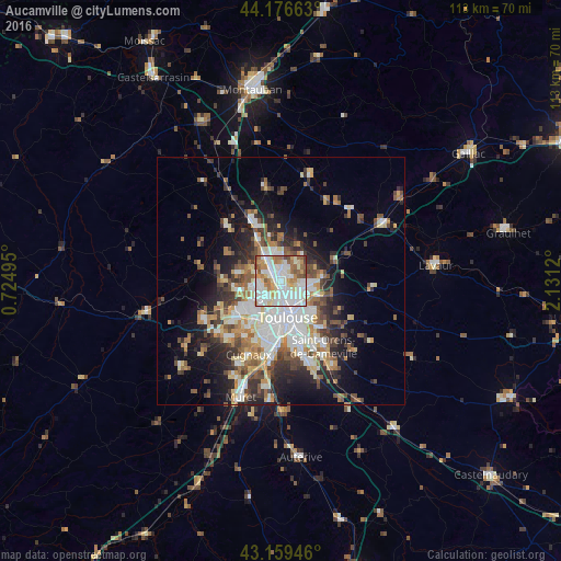
Analysis of Aucamville night lights 2016
Square area 10x10 km:
 31.97%
90-99
27.88%80-89
9.7%70-79
8.33%60-69
10.76%50-59
8.48%40-49
2.27%30-39
0.61%20-29
0%10-19
0%0-9
0%Square area 50x50 km:
5.06%90-99
5.33%80-89
2.77%70-79
2.47%60-69
3.22%50-59
3.35%40-49
3.64%30-39
3.36%20-29
5.51%10-19
8.57%0-9
56.73%Clear (daylight) street map image can be seen on geolist.org.
Map coordinates:
44° 10' 35.9" North, 0° 43' 29.8" East
43° 40' 12.7" North, 1° 25' 41.1" East
43° 9' 34.1" North, 2° 7' 52.3" East
Some cities around Aucamville sort by population:
• Toulouse
7.4 km =4.6 mi,  170°
170°
• Blagnac
5 km =3.1 mi,  213°
213°
• L'Union
4.5 km =2.8 mi,  103°
103°
• Saint-Jean
5.8 km =3.6 mi, 96°
• Castelginest
2.7 km =1.7 mi,  10°
10°
• Beauzelle
4.3 km =2.7 mi,  265°
265°
• Launaguet
2.4 km =1.5 mi,  68°
68°
• Saint-Alban
2.9 km =1.8 mi,  330°
330°
3036287 (p: 6,202)
Sources (retrieved 2019-11-25):
» Earth at Night: Flat Maps 2012, 2016