Petit-Couronne night lights from space
Night Light of Petit-Couronne (Normandy) from space (France) Src. Average luminocity for 10x10km area is 54.8529% and for 50x50km: 16.1608%.
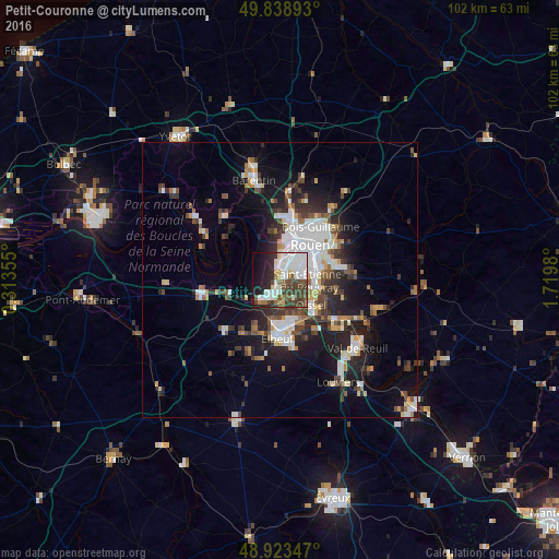
Analysis of Petit-Couronne night lights 2016
Square area 10x10 km:
 19.65%
90-99
11.63%80-89
3.61%70-79
2.14%60-69
2.94%50-59
6.15%40-49
12.57%30-39
10.16%20-29
10.96%10-19
12.97%0-9
7.22%Square area 50x50 km:
3.59%90-99
3.13%80-89
1.07%70-79
1.38%60-69
1.51%50-59
1.87%40-49
2.21%30-39
2.88%20-29
4.56%10-19
9.13%0-9
68.68%Clear (daylight) street map image can be seen on geolist.org.
Map coordinates:
49° 50' 20.1" North, 0° 18' 48.8" East
49° 22' 60" North, 1° 1' 0" East
48° 55' 24.5" North, 1° 43' 11.3" East
Some cities around Petit-Couronne sort by population:
• Sotteville-lès-Rouen
6.1 km =3.8 mi,  61°
61°
• Saint-Étienne-du-Rouvray
6.4 km =4 mi,  95°
95°
• Le Grand-Quevilly
2.9 km =1.8 mi,  47°
47°
• Le Petit-Quevilly
4.7 km =2.9 mi,  44°
44°
• Canteleu
6.4 km =4 mi,  5°
5°
• Oissel
7.9 km =4.9 mi,  134°
134°
• Grand-Couronne
3.2 km =2 mi,  193°
193°
• Cléon
7.9 km =4.9 mi,  173°
173°
3002918 (p: 8,761)
Sources (retrieved 2019-11-25):
» Earth at Night: Flat Maps 2012, 2016