Ramonville-Saint-Agne night lights from space
Night Light of Ramonville-Saint-Agne (Occitanie) from space (France) Src. Average luminocity for 10x10km area is 75.5651% and for 50x50km: 24.5659%.
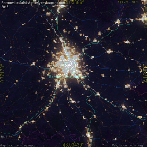
Analysis of Ramonville-Saint-Agne night lights 2016
Square area 10x10 km:
 24.76%
90-99
24.76%80-89
8.25%70-79
5.71%60-69
5.4%50-59
5.56%40-49
9.68%30-39
7.94%20-29
7.94%10-19
0%0-9
0%Square area 50x50 km:
4.97%90-99
5.19%80-89
2.74%70-79
2.45%60-69
3.13%50-59
3.38%40-49
3.68%30-39
3.24%20-29
5.71%10-19
8.65%0-9
56.86%Clear (daylight) street map image can be seen on geolist.org.
Map coordinates:
44° 3' 13.2" North, 0° 46' 18.4" East
43° 32' 46.2" North, 1° 28' 29.7" East
43° 2' 3.8" North, 2° 10' 40.9" East
Some cities around Ramonville-Saint-Agne sort by population:
• Toulouse
6.9 km =4.3 mi,  338°
338°
• Balma
7.5 km =4.7 mi,  15°
15°
• Cugnaux
10.6 km =6.6 mi,  264°
264°
• Saint-Orens-de-Gameville
4.8 km =3 mi,  79°
79°
• Castanet-Tolosan
3.9 km =2.4 mi,  150°
150°
• Portet-sur-Garonne
6.1 km =3.8 mi,  245°
245°
• Villeneuve-Tolosane
11.1 km =6.9 mi, 256°
• Escalquens
7.5 km =4.7 mi,  115°
115°
2984493 (p: 12,573)
Sources (retrieved 2019-11-25):
» Earth at Night: Flat Maps 2012, 2016