Castanet-Tolosan night lights from space
Night Light of Castanet-Tolosan (Occitanie) from space (France) Src. Average luminocity for 10x10km area is 53.8016% and for 50x50km: 23.7339%.
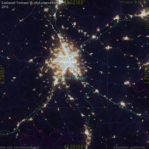
Analysis of Castanet-Tolosan night lights 2016
Square area 10x10 km:
 9.68%
9.68%90-99
14.76%80-89
6.83%70-79
3.97%60-69
8.41%50-59
6.03%40-49
8.25%30-39
5.71%20-29
17.14%10-19
19.05%0-9
0.16%Square area 50x50 km:
4.92%90-99
5.1%80-89
2.59%70-79
2.38%60-69
3.08%50-59
3.32%40-49
3.58%30-39
3.16%20-29
5.14%10-19
7.81%0-9
58.93%Clear (daylight) street map image can be seen on geolist.org.
Map coordinates:
44° 1' 25.1" North, 0° 47' 43.8" East
43° 30' 57.3" North, 1° 29' 55.1" East
43° 0' 13.9" North, 2° 12' 6.3" East
Some cities around Castanet-Tolosan sort by population:
• Toulouse
10.8 km =6.7 mi,  335°
335°
• Balma
10.6 km =6.6 mi,  0°
0°
• Saint-Orens-de-Gameville
5.1 km =3.2 mi,  34°
34°
• Ramonville-Saint-Agne
3.9 km =2.4 mi,  330°
330°
• Portet-sur-Garonne
7.5 km =4.7 mi,  276°
276°
• Villeneuve-Tolosane
12.7 km =7.9 mi,  273°
273°
• Escalquens
4.9 km =3 mi,  87°
87°
• Labarthe-sur-Lèze
10.7 km =6.6 mi,  228°
228°
3028409 (p: 11,561)
Sources (retrieved 2019-11-25):
» Earth at Night: Flat Maps 2012, 2016