Unieux night lights from space
Night Light of Unieux (Auvergne-Rhône-Alpes) from space (France) Src. Average luminocity for 10x10km area is 38.6079% and for 50x50km: 12.8129%.
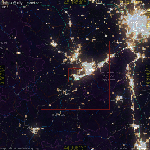
Analysis of Unieux night lights 2016
Square area 10x10 km:
 8.25%
8.25%90-99
7.14%80-89
5.56%70-79
2.7%60-69
2.22%50-59
4.76%40-49
5.24%30-39
7.94%20-29
13.81%10-19
22.7%0-9
19.68%Square area 50x50 km:
2.03%90-99
2.43%80-89
1.07%70-79
1.06%60-69
1.54%50-59
1.49%40-49
1.89%30-39
1.84%20-29
4.81%10-19
9.23%0-9
72.59%Clear (daylight) street map image can be seen on geolist.org.
Map coordinates:
45° 53' 43.7" North, 3° 34' 4.2" East
45° 24' 14.2" North, 4° 16' 15.4" East
44° 54' 29.3" North, 4° 58' 26.7" East
Some cities around Unieux sort by population:
• Saint-Étienne
9.9 km =6.2 mi,  70°
70°
• Firminy
2.1 km =1.3 mi,  139°
139°
• Le Chambon-Feugerolles
4.2 km =2.6 mi,  109°
109°
• Roche-la-Molière
5.4 km =3.4 mi,  56°
56°
• Villars
9.7 km =6 mi,  42°
42°
• La Ricamarie
7.7 km =4.8 mi,  88°
88°
• Saint-Genest-Lerpt
6.9 km =4.3 mi,  50°
50°
• Aurec-sur-Loire
6.7 km =4.2 mi,  234°
234°
2971377 (p: 8,456)
Sources (retrieved 2019-11-25):
» Earth at Night: Flat Maps 2012, 2016