Saint-Julien-en-Genevois night lights from space
Night Light of Saint-Julien-en-Genevois (Auvergne-Rhône-Alpes) from space (France) Src. Average luminocity for 10x10km area is 38.7557% and for 50x50km: 17.2917%.
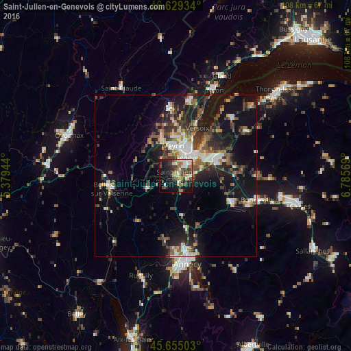
Analysis of Saint-Julien-en-Genevois night lights 2016
Square area 10x10 km:
 5.68%
5.68%90-99
5.97%80-89
3.55%70-79
3.55%60-69
8.81%50-59
3.84%40-49
8.66%30-39
9.38%20-29
8.81%10-19
26.85%0-9
14.91%Square area 50x50 km:
2.2%90-99
2.91%80-89
1.4%70-79
1.54%60-69
2.26%50-59
2.56%40-49
3.39%30-39
3.47%20-29
5.02%10-19
14.39%0-9
60.87%Clear (daylight) street map image can be seen on geolist.org.
Map coordinates:
46° 37' 45.6" North, 5° 22' 46" East
46° 8' 39.6" North, 6° 4' 57.2" East
45° 39' 18.1" North, 6° 47' 8.5" East
Some cities around Saint-Julien-en-Genevois sort by population:
• Genève, CH
8.1 km =5 mi,  37°
37°
• Vernier, CH
8.1 km =5 mi,  1°
1°
• Lancy, CH
5.6 km =3.5 mi,  25°
25°
• Carouge, CH
6 km =3.7 mi,  46°
46°
• Onex, CH
4.7 km =2.9 mi,  19°
19°
• Plan-les-Ouates, CH
3.7 km =2.3 mi, 45°
• Veyrier, CH
8.2 km =5.1 mi,  72°
72°
• Bernex, CH
3.6 km =2.2 mi,  351°
351°
2979072 (p: 10,108)
Sources (retrieved 2019-11-25):
» Earth at Night: Flat Maps 2012, 2016