Veyrier night lights from space
Night Light of Veyrier (Geneva) from space (Switzerland) Src. Average luminocity for 10x10km area is 56.2841% and for 50x50km: 18.4168%.
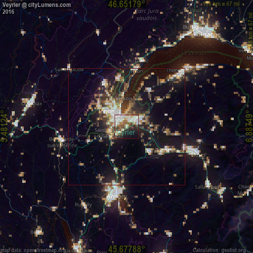
Analysis of Veyrier night lights 2016
Square area 10x10 km:
 15.91%
90-99
15.63%80-89
4.55%70-79
2.56%60-69
6.39%50-59
6.53%40-49
9.66%30-39
5.54%20-29
11.51%10-19
16.62%0-9
5.11%Square area 50x50 km:
2.26%90-99
3.12%80-89
1.29%70-79
1.64%60-69
2.31%50-59
2.8%40-49
3.66%30-39
3.57%20-29
5.37%10-19
17.4%0-9
56.58%Clear (daylight) street map image can be seen on geolist.org.
Map coordinates:
46° 39' 6.4" North, 5° 28' 52.5" East
46° 10' 1.2" North, 6° 11' 3.7" East
45° 40' 40.4" North, 6° 53' 15" East
Some cities around Veyrier sort by population:
• Genève
4.9 km =3 mi,  322°
322°
• Annemasse, FR
5.1 km =3.2 mi,  53°
53°
• Carouge
3.8 km =2.4 mi,  294°
294°
• Thônex
2.6 km =1.6 mi,  25°
25°
• Gaillard, FR
2.7 km =1.7 mi,  40°
40°
• Plan-les-Ouates
5.2 km =3.2 mi,  271°
271°
• Chêne-Bougeries
3.5 km =2.2 mi,  2°
2°
• Chêne-Bourg
3.2 km =2 mi,  13°
13°
2658143 (p: 9,800)
Sources (retrieved 2019-11-25):
» Earth at Night: Flat Maps 2012, 2016