Plan-les-Ouates night lights from space
Night Light of Plan-les-Ouates (Geneva) from space (Switzerland) Src. Average luminocity for 10x10km area is 61.6776% and for 50x50km: 17.7054%.
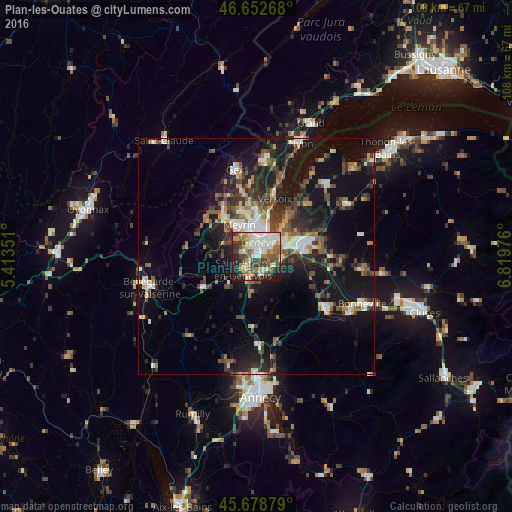
Analysis of Plan-les-Ouates night lights 2016
Square area 10x10 km:
 14.06%
90-99
14.91%80-89
6.53%70-79
6.53%60-69
10.65%50-59
6.53%40-49
10.09%30-39
11.93%20-29
9.09%10-19
9.52%0-9
0.14%Square area 50x50 km:
2.18%90-99
2.91%80-89
1.35%70-79
1.61%60-69
2.29%50-59
2.54%40-49
3.54%30-39
3.53%20-29
5.15%10-19
15.87%0-9
59.03%Clear (daylight) street map image can be seen on geolist.org.
Map coordinates:
46° 39' 9.6" North, 5° 24' 48.6" East
46° 10' 4.4" North, 6° 6' 59.9" East
45° 40' 43.6" North, 6° 49' 11.1" East
Some cities around Plan-les-Ouates sort by population:
• Genève
4.4 km =2.7 mi,  30°
30°
• Vernier
6 km =3.7 mi,  335°
335°
• Lancy
2.4 km =1.5 mi,  355°
355°
• Carouge
2.3 km =1.4 mi,  50°
50°
• Onex
2.1 km =1.3 mi,  328°
328°
• Saint-Julien-en-Genevois, FR
3.7 km =2.3 mi,  225°
225°
• Veyrier
5.2 km =3.2 mi,  91°
91°
• Bernex
3.3 km =2.1 mi,  286°
286°
2659190 (p: 10,540)
Sources (retrieved 2019-11-25):
» Earth at Night: Flat Maps 2012, 2016