Les Avanchets night lights from space
Night Light of Les Avanchets (Geneva) from space (Switzerland) Src. Average luminocity for 10x10km area is 75.7145% and for 50x50km: 17.4458%.
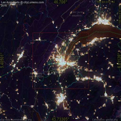
Analysis of Les Avanchets night lights 2016
Square area 10x10 km:
 24.43%
90-99
24.57%80-89
5.68%70-79
7.1%60-69
10.09%50-59
4.26%40-49
7.39%30-39
12.22%20-29
3.84%10-19
0.43%0-9
0%Square area 50x50 km:
2.23%90-99
2.85%80-89
1.41%70-79
1.66%60-69
2.18%50-59
2.5%40-49
3.39%30-39
3.43%20-29
4.63%10-19
15.33%0-9
60.41%Clear (daylight) street map image can be seen on geolist.org.
Map coordinates:
46° 42' 21.6" North, 5° 24' 18" East
46° 13' 18" North, 6° 6' 29.3" East
45° 43' 59" North, 6° 48' 40.5" East
Some cities around Les Avanchets sort by population:
• Genève
3.6 km =2.2 mi,  126°
126°
• Vernier
1.9 km =1.2 mi,  253°
253°
• Lancy
3.6 km =2.2 mi,  172°
172°
• Meyrin
2.6 km =1.6 mi,  303°
303°
• Carouge
5.1 km =3.2 mi,  152°
152°
• Onex
4.2 km =2.6 mi,  186°
186°
• Le Grand-Saconnex
1.5 km =0.9 mi,  40°
40°
• Ferney-Voltaire, FR
4.1 km =2.5 mi,  2°
2°
7779000 (p: 5,730)
Sources (retrieved 2019-11-25):
» Earth at Night: Flat Maps 2012, 2016