Craponne night lights from space
Night Light of Craponne (Auvergne-Rhône-Alpes) from space (France) Src. Average luminocity for 10x10km area is 58.7652% and for 50x50km: 31.013%.
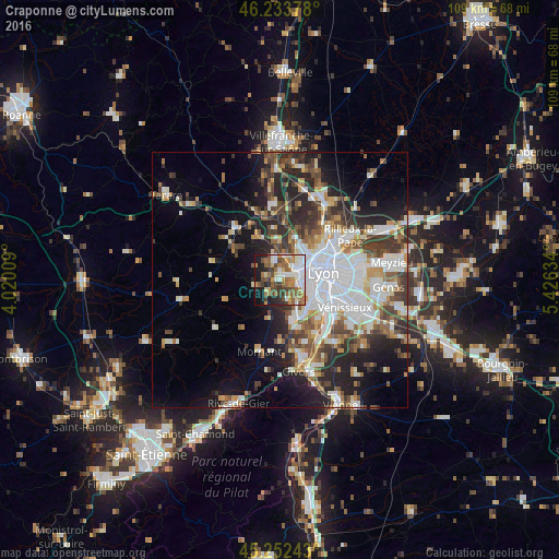
Analysis of Craponne night lights 2016
Square area 10x10 km:
 11.52%
90-99
13.94%80-89
3.48%70-79
7.88%60-69
13.18%50-59
12.58%40-49
7.73%30-39
6.67%20-29
8.64%10-19
12.58%0-9
1.82%Square area 50x50 km:
8.04%90-99
6.4%80-89
2.46%70-79
3.05%60-69
3.48%50-59
4.08%40-49
4.32%30-39
4.83%20-29
7.68%10-19
10.4%0-9
45.24%Clear (daylight) street map image can be seen on geolist.org.
Map coordinates:
46° 14' 1.6" North, 4° 1' 12.3" East
45° 44' 42.9" North, 4° 43' 23.6" East
45° 15' 8.7" North, 5° 25' 34.8" East
Some cities around Craponne sort by population:
• Sainte-Foy-lès-Lyon
6.3 km =3.9 mi,  101°
101°
• Écully
5.3 km =3.3 mi,  52°
52°
• Tassin-la-Demi-Lune
5.2 km =3.2 mi,  77°
77°
• Francheville
3.3 km =2.1 mi,  107°
107°
• Dardilly
7.1 km =4.4 mi,  19°
19°
• Chaponost
4.2 km =2.6 mi,  159°
159°
• La Mulatière
7.2 km =4.5 mi, 105°
• Saint-Genis-les-Ollières
1.3 km =0.8 mi,  10°
10°
3022683 (p: 8,460)
Sources (retrieved 2019-11-25):
» Earth at Night: Flat Maps 2012, 2016