Chaponost night lights from space
Night Light of Chaponost (Auvergne-Rhône-Alpes) from space (France) Src. Average luminocity for 10x10km area is 59.9348% and for 50x50km: 32.1821%.
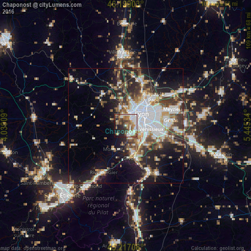
Analysis of Chaponost night lights 2016
Square area 10x10 km:
 12.88%
90-99
15.3%80-89
6.06%70-79
5.76%60-69
9.7%50-59
11.21%40-49
8.03%30-39
7.27%20-29
11.67%10-19
9.85%0-9
2.27%Square area 50x50 km:
8.23%90-99
6.73%80-89
2.5%70-79
3.23%60-69
3.57%50-59
4.06%40-49
4.45%30-39
4.98%20-29
8.08%10-19
12.15%0-9
42.01%Clear (daylight) street map image can be seen on geolist.org.
Map coordinates:
46° 11' 56.5" North, 4° 2' 20.7" East
45° 42' 36.7" North, 4° 44' 32" East
45° 13' 1.4" North, 5° 26' 43.2" East
Some cities around Chaponost sort by population:
• Oullins
5.1 km =3.2 mi,  85°
85°
• Sainte-Foy-lès-Lyon
5.4 km =3.4 mi,  60°
60°
• Saint-Genis-Laval
4.3 km =2.7 mi,  112°
112°
• Brignais
4.1 km =2.5 mi,  167°
167°
• Francheville
3.3 km =2.1 mi,  29°
29°
• Craponne
4.2 km =2.6 mi,  339°
339°
• La Mulatière
5.8 km =3.6 mi,  69°
69°
• Saint-Genis-les-Ollières
5.4 km =3.4 mi,  346°
346°
3026757 (p: 8,286)
Sources (retrieved 2019-11-25):
» Earth at Night: Flat Maps 2012, 2016