Saint-Christol-lès-Alès night lights from space
Night Light of Saint-Christol-lès-Alès (Occitanie) from space (France) Src. Average luminocity for 10x10km area is 32.753% and for 50x50km: 7.7756%.
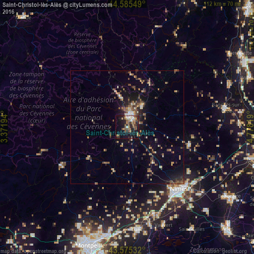
Analysis of Saint-Christol-lès-Alès night lights 2016
Square area 10x10 km:
 2.42%
2.42%90-99
4.55%80-89
2.12%70-79
5.3%60-69
6.21%50-59
7.27%40-49
5.3%30-39
5.76%20-29
11.06%10-19
28.79%0-9
21.21%Square area 50x50 km:
0.24%90-99
0.86%80-89
0.7%70-79
1.05%60-69
1.36%50-59
1.41%40-49
1.44%30-39
1.34%20-29
2.42%10-19
5.08%0-9
84.09%Clear (daylight) street map image can be seen on geolist.org.
Map coordinates:
44° 35' 7.8" North, 3° 22' 19" East
44° 4' 57.2" North, 4° 4' 30.2" East
43° 34' 31.2" North, 4° 46' 41.5" East
Some cities around Saint-Christol-lès-Alès sort by population:
• Nîmes
35.8 km =22.2 mi,  140°
140°
• Alès
4.7 km =2.9 mi,  5°
5°
• Bagnols-sur-Cèze
44.2 km =27.5 mi,  78°
78°
• Marguerittes
38.6 km =24 mi,  129°
129°
• Uzès
28.3 km =17.6 mi,  105°
105°
• Manduel
43.3 km =26.9 mi, 132°
• Bouillargues
42.5 km =26.4 mi, 138°
• Milhaud
37.6 km =23.4 mi,  149°
149°
2981173 (p: 6,113)
Sources (retrieved 2019-11-25):
» Earth at Night: Flat Maps 2012, 2016