Alès night lights from space
Night Light of Alès (Occitanie) from space (France) Src. Average luminocity for 10x10km area is 45.5197% and for 50x50km: 7.2422%.
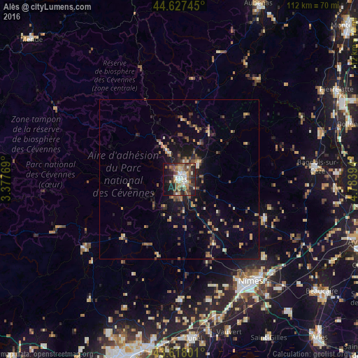

Analysis of Alès night lights 2016
Square area 10x10 km:
 5.15%
5.15%90-99
8.48%80-89
4.85%70-79
5%60-69
8.94%50-59
9.24%40-49
8.48%30-39
8.18%20-29
17.42%10-19
17.42%0-9
6.82%Square area 50x50 km:
0.24%90-99
0.83%80-89
0.67%70-79
1.06%60-69
1.26%50-59
1.33%40-49
1.27%30-39
1.26%20-29
2.02%10-19
4.44%0-9
85.62%Clear (daylight) street map image can be seen on geolist.org.
Map coordinates:
44° 37' 38.8" North, 3° 22' 39.7" East
44° 7' 29.6" North, 4° 4' 51" East
43° 37' 4.8" North, 4° 47' 2.2" East
Some cities around Alès sort by population:
• Nîmes
39.3 km =24.4 mi,  145°
145°
• Bagnols-sur-Cèze
43 km =26.7 mi,  84°
84°
• Marguerittes
41.5 km =25.8 mi,  135°
135°
• Uzès
29.4 km =18.3 mi,  114°
114°
• Manduel
46.3 km =28.8 mi, 137°
• Saint-Christol-lès-Alès
4.7 km =2.9 mi,  185°
185°
• Bouillargues
45.8 km =28.5 mi, 142°
• Milhaud
41.5 km =25.8 mi, 153°
3038224 (p: 42,410)
Sources (retrieved 2019-11-25):
» Earth at Night: Flat Maps 2012, 2016