Bagnols-sur-Cèze night lights from space
Night Light of Bagnols-sur-Cèze (Occitanie) from space (France) Src. Average luminocity for 10x10km area is 22.0848% and for 50x50km: 15.9251%.
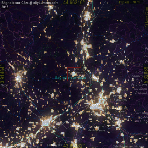
Analysis of Bagnols-sur-Cèze night lights 2016
Square area 10x10 km:
 2.88%
2.88%90-99
2.73%80-89
1.67%70-79
2.42%60-69
2.73%50-59
2.42%40-49
2.88%30-39
1.36%20-29
3.64%10-19
43.94%0-9
33.33%Square area 50x50 km:
1.81%90-99
2.72%80-89
1.78%70-79
2.01%60-69
2.15%50-59
1.76%40-49
2.09%30-39
1.79%20-29
3.9%10-19
16.04%0-9
63.93%Clear (daylight) street map image can be seen on geolist.org.
Map coordinates:
44° 39' 43.8" North, 3° 54' 52.7" East
44° 9' 35.6" North, 4° 37' 3.9" East
43° 39' 12" North, 5° 19' 15.2" East
Some cities around Bagnols-sur-Cèze sort by population:
• Orange
15.5 km =9.6 mi,  98°
98°
• Bollène
17.1 km =10.6 mi,  37°
37°
• Pont-Saint-Esprit
10.8 km =6.7 mi,  12°
12°
• Uzès
22.9 km =14.2 mi,  224°
224°
• Rochefort-du-Gard
21.2 km =13.2 mi,  164°
164°
• Courthézon
22.7 km =14.1 mi,  110°
110°
• Laudun-l'Ardoise
7.7 km =4.8 mi,  149°
149°
• Roquemaure
17.7 km =11 mi,  133°
133°
3035396 (p: 19,640)
Sources (retrieved 2019-11-25):
» Earth at Night: Flat Maps 2012, 2016