Reichshoffen night lights from space
Night Light of Reichshoffen (Grand Est) from space (France) Src. Average luminocity for 10x10km area is 17.5455% and for 50x50km: 8.9849%.
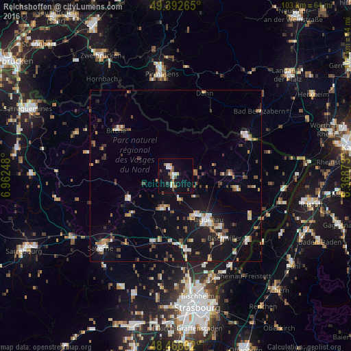
Analysis of Reichshoffen night lights 2016
Square area 10x10 km:
 2.41%
2.41%90-99
3.27%80-89
0.57%70-79
2.13%60-69
2.41%50-59
1.42%40-49
3.41%30-39
0.57%20-29
0.57%10-19
19.89%0-9
63.35%Square area 50x50 km:
0.98%90-99
1.17%80-89
0.81%70-79
1.02%60-69
1.02%50-59
1.11%40-49
1.41%30-39
1.11%20-29
1.19%10-19
9.05%0-9
81.12%Clear (daylight) street map image can be seen on geolist.org.
Map coordinates:
49° 23' 33.5" North, 6° 57' 44.9" East
48° 55' 58.3" North, 7° 39' 56.2" East
48° 28' 7.8" North, 8° 22' 7.4" East
Some cities around Reichshoffen sort by population:
• Pirmasens, DE
30.2 km =18.8 mi,  351°
351°
• Haguenau
15.9 km =9.9 mi,  144°
144°
• Saverne
30.7 km =19.1 mi,  226°
226°
• Bischwiller
22.9 km =14.2 mi, 143°
• Brumath
22.4 km =13.9 mi,  171°
171°
• Wissembourg
23.5 km =14.6 mi,  60°
60°
• Vendenheim
29.5 km =18.3 mi, 173°
• Bitche
21.7 km =13.5 mi,  307°
307°
2984136 (p: 5,539)
Sources (retrieved 2019-11-25):
» Earth at Night: Flat Maps 2012, 2016