Wissembourg night lights from space
Night Light of Wissembourg (Grand Est) from space (France) Src. Average luminocity for 10x10km area is 10.5863% and for 50x50km: 8.9746%.
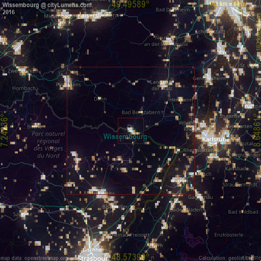
Analysis of Wissembourg night lights 2016
Square area 10x10 km:
 1.93%
1.93%90-99
1.49%80-89
1.93%70-79
0.3%60-69
0.6%50-59
1.64%40-49
1.19%30-39
1.34%20-29
0.15%10-19
1.64%0-9
87.8%Square area 50x50 km:
0.82%90-99
1.2%80-89
0.9%70-79
0.95%60-69
0.91%50-59
1.27%40-49
1.58%30-39
1.26%20-29
1.14%10-19
7.67%0-9
82.31%Clear (daylight) street map image can be seen on geolist.org.
Map coordinates:
49° 29' 45.2" North, 7° 14' 32.5" East
49° 2' 13.5" North, 7° 56' 43.7" East
48° 34' 26.4" North, 8° 38' 55" East
Some cities around Wissembourg sort by population:
• Landau in der Pfalz, DE
21.9 km =13.6 mi,  34°
34°
• Wörth am Rhein, DE
22.9 km =14.2 mi,  86°
86°
• Kandel, DE
19 km =11.8 mi,  74°
74°
• Bad Bergzabern, DE
8.3 km =5.2 mi, 29°
• Annweiler am Trifels, DE
18.9 km =11.7 mi,  6°
6°
• Jockgrim, DE
24.8 km =15.4 mi,  75°
75°
• Reichshoffen
23.5 km =14.6 mi,  240°
240°
• Hagenbach, DE
22.3 km =13.9 mi,  95°
95°
2967325 (p: 8,800)
Sources (retrieved 2019-11-25):
» Earth at Night: Flat Maps 2012, 2016