Quéven night lights from space
Night Light of Quéven (Brittany) from space (France) Src. Average luminocity for 10x10km area is 35.5967% and for 50x50km: 5.1737%.
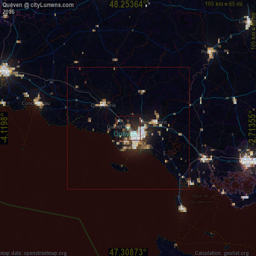
Analysis of Quéven night lights 2016
Square area 10x10 km:
 9.38%
9.38%90-99
8.33%80-89
1.04%70-79
2.83%60-69
0.45%50-59
4.02%40-49
5.51%30-39
5.51%20-29
14.58%10-19
25%0-9
23.36%Square area 50x50 km:
0.77%90-99
0.89%80-89
0.45%70-79
0.32%60-69
0.57%50-59
0.81%40-49
0.83%30-39
0.82%20-29
1.7%10-19
3.53%0-9
89.31%Clear (daylight) street map image can be seen on geolist.org.
Map coordinates:
48° 15' 13.1" North, 4° 7' 11.3" West
47° 46' 60" North, 3° 25' 0" West
47° 18' 31.4" North, 2° 42' 48.8" West
Some cities around Quéven sort by population:
• Lorient
5.6 km =3.5 mi,  137°
137°
• Lanester
6.3 km =3.9 mi,  113°
113°
• Ploemeur
5.7 km =3.5 mi,  192°
192°
• Hennebont
11 km =6.8 mi,  77°
77°
• Quimperlé
13.6 km =8.5 mi,  312°
312°
• Guidel-Plage
8 km =5 mi,  257°
257°
• Larmor-Plage
8.9 km =5.5 mi,  163°
163°
• Caudan
6.2 km =3.9 mi,  62°
62°
2984760 (p: 9,316)
Sources (retrieved 2019-11-25):
» Earth at Night: Flat Maps 2012, 2016