Guidel-Plage night lights from space
Night Light of Guidel-Plage (Brittany) from space (France) Src. Average luminocity for 10x10km area is 7.0253% and for 50x50km: 5.079%.
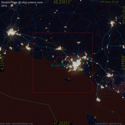
Analysis of Guidel-Plage night lights 2016
Square area 10x10 km:
 0.3%
0.3%90-99
0%80-89
0.6%70-79
1.49%60-69
0.89%50-59
1.93%40-49
0.74%30-39
1.79%20-29
1.49%10-19
4.91%0-9
85.86%Square area 50x50 km:
0.79%90-99
0.91%80-89
0.42%70-79
0.32%60-69
0.55%50-59
0.75%40-49
0.78%30-39
0.8%20-29
1.72%10-19
3.49%0-9
89.46%Clear (daylight) street map image can be seen on geolist.org.
Map coordinates:
48° 14' 17.3" North, 4° 13' 29.7" West
47° 46' 3.6" North, 3° 31' 18.5" West
47° 17' 34.5" North, 2° 49' 7.2" West
Some cities around Guidel-Plage sort by population:
• Lorient
11.9 km =7.4 mi,  101°
101°
• Lanester
13.6 km =8.5 mi,  92°
92°
• Ploemeur
7.6 km =4.7 mi,  120°
120°
• Quimperlé
11.2 km =7 mi,  349°
349°
• Quéven
8 km =5 mi,  77°
77°
• Larmor-Plage
12.4 km =7.7 mi, 123°
• Caudan
14.2 km =8.8 mi,  71°
71°
• Moëlan-sur-Mer
9.5 km =5.9 mi,  302°
302°
3232493 (p: 9,800)
Sources (retrieved 2019-11-25):
» Earth at Night: Flat Maps 2012, 2016