Cébazat night lights from space
Night Light of Cébazat (Auvergne-Rhône-Alpes) from space (France) Src. Average luminocity for 10x10km area is 41.9122% and for 50x50km: 7.9023%.
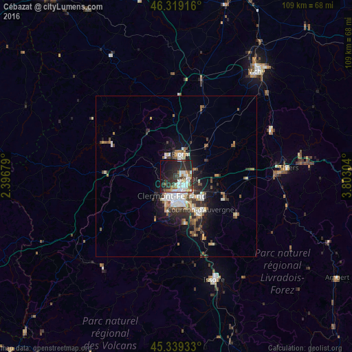
Analysis of Cébazat night lights 2016
Square area 10x10 km:
 9.08%
9.08%90-99
9.97%80-89
3.57%70-79
1.64%60-69
3.87%50-59
4.91%40-49
2.98%30-39
9.23%20-29
22.92%10-19
21.43%0-9
10.42%Square area 50x50 km:
1.36%90-99
1.59%80-89
0.64%70-79
0.61%60-69
0.92%50-59
1.17%40-49
1.04%30-39
1.25%20-29
2.62%10-19
4.69%0-9
84.12%Clear (daylight) street map image can be seen on geolist.org.
Map coordinates:
46° 19' 9" North, 2° 23' 48.4" East
45° 49' 53" North, 3° 5' 59.7" East
45° 20' 21.6" North, 3° 48' 10.9" East
Some cities around Cébazat sort by population:
• Clermont-Ferrand
5.8 km =3.6 mi,  190°
190°
• Chamalières
6.9 km =4.3 mi,  201°
201°
• Riom
7 km =4.3 mi,  8°
8°
• Beaumont
9 km =5.6 mi, 188°
• Aubière
9 km =5.6 mi,  174°
174°
• Gerzat
3.5 km =2.2 mi,  100°
100°
• Romagnat
11.3 km =7 mi,  179°
179°
• Châtel-Guyon
10.5 km =6.5 mi,  344°
344°
3028028 (p: 8,114)
Sources (retrieved 2019-11-25):
» Earth at Night: Flat Maps 2012, 2016