Souppes-sur-Loing night lights from space
Night Light of Souppes-sur-Loing (Île-de-France) from space (France) Src. Average luminocity for 10x10km area is 7.9464% and for 50x50km: 6.2664%.
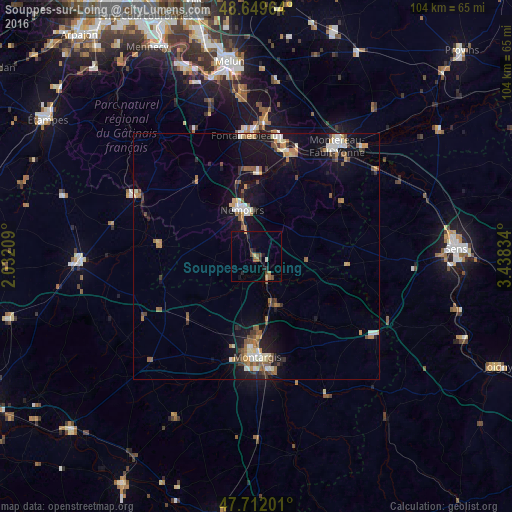
Analysis of Souppes-sur-Loing night lights 2016
Square area 10x10 km:
 0%
0%90-99
0.6%80-89
0.6%70-79
0.89%60-69
1.64%50-59
1.34%40-49
2.38%30-39
1.04%20-29
2.23%10-19
3.27%0-9
86.01%Square area 50x50 km:
0.63%90-99
1.04%80-89
0.51%70-79
0.8%60-69
0.93%50-59
1.11%40-49
0.84%30-39
0.7%20-29
0.84%10-19
5.88%0-9
86.7%Clear (daylight) street map image can be seen on geolist.org.
Map coordinates:
48° 38' 58.7" North, 2° 1' 55.5" East
48° 10' 58.7" North, 2° 44' 6.8" East
47° 42' 43.2" North, 3° 26' 18" East
Some cities around Souppes-sur-Loing sort by population:
• Montargis
20.7 km =12.9 mi,  180°
180°
• Châlette-sur-Loing
18.9 km =11.7 mi, 179°
• Nemours
10.8 km =6.7 mi,  342°
342°
• Amilly
23.5 km =14.6 mi,  173°
173°
• Champagne-sur-Seine
24.3 km =15.1 mi,  10°
10°
• Villemandeur
21.8 km =13.5 mi, 183°
• Saint-Pierre-lès-Nemours
10.2 km =6.3 mi, 336°
• Veneux-les-Sablons
22.2 km =13.8 mi, 11°
2973963 (p: 6,002)
Sources (retrieved 2019-11-25):
» Earth at Night: Flat Maps 2012, 2016