Châteauneuf-sur-Loire night lights from space
Night Light of Châteauneuf-sur-Loire (Centre) from space (France) Src. Average luminocity for 10x10km area is 7.6932% and for 50x50km: 6.4839%.
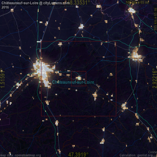
Analysis of Châteauneuf-sur-Loire night lights 2016
Square area 10x10 km:
 0%
0%90-99
1.42%80-89
1.42%70-79
0.57%60-69
2.13%50-59
0.14%40-49
2.41%30-39
0.43%20-29
0.57%10-19
0%0-9
90.91%Square area 50x50 km:
1.37%90-99
1.45%80-89
0.46%70-79
0.51%60-69
0.7%50-59
0.85%40-49
0.97%30-39
0.86%20-29
1.5%10-19
2.57%0-9
88.77%Clear (daylight) street map image can be seen on geolist.org.
Map coordinates:
48° 20' 7.1" North, 1° 30' 57.3" East
47° 51' 56.7" North, 2° 13' 8.5" East
47° 23' 30.8" North, 2° 55' 19.8" East
Some cities around Châteauneuf-sur-Loire sort by population:
• Orléans
23.9 km =14.9 mi,  279°
279°
• Olivet
23.9 km =14.9 mi,  269°
269°
• Fleury-les-Aubrais
23.7 km =14.7 mi,  288°
288°
• Saint-Jean-de-Braye
18.8 km =11.7 mi, 286°
• Saint-Jean-le-Blanc
22.8 km =14.2 mi, 277°
• Chécy
14.9 km =9.3 mi, 282°
• Saint-Denis-en-Val
18.9 km =11.7 mi, 272°
• Sully-sur-Loire
16.1 km =10 mi,  134°
134°
3026222 (p: 7,446)
Sources (retrieved 2019-11-25):
» Earth at Night: Flat Maps 2012, 2016