Pérols night lights from space
Night Light of Pérols (Occitanie) from space (France) Src. Average luminocity for 10x10km area is 48.1968% and for 50x50km: 22.8579%.
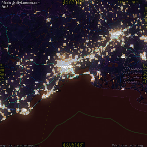
Analysis of Pérols night lights 2016
Square area 10x10 km:
 11.11%
90-99
13.49%80-89
2.86%70-79
4.29%60-69
5.24%50-59
4.13%40-49
3.97%30-39
7.78%20-29
19.84%10-19
20.79%0-9
6.51%Square area 50x50 km:
4.33%90-99
4.87%80-89
2.62%70-79
2.32%60-69
2.35%50-59
1.69%40-49
1.71%30-39
2.89%20-29
8.89%10-19
18.65%0-9
49.69%Clear (daylight) street map image can be seen on geolist.org.
Map coordinates:
44° 4' 13.7" North, 3° 14' 56.1" East
43° 33' 47.3" North, 3° 57' 7.3" East
43° 3' 5.3" North, 4° 39' 18.6" East
Some cities around Pérols sort by population:
• Montpellier
8 km =5 mi,  311°
311°
• Mauguio
7.6 km =4.7 mi,  36°
36°
• Castelnau-le-Lez
8.9 km =5.5 mi,  331°
331°
• Lattes
3.9 km =2.4 mi,  277°
277°
• Saint-Jean-de-Védas
10.3 km =6.4 mi, 279°
• Villeneuve-lès-Maguelone
7.6 km =4.7 mi,  244°
244°
• Le Crès
9.5 km =5.9 mi,  354°
354°
• Palavas-les-Flots
4.4 km =2.7 mi,  207°
207°
2987936 (p: 8,753)
Sources (retrieved 2019-11-25):
» Earth at Night: Flat Maps 2012, 2016