Palavas-les-Flots night lights from space
Night Light of Palavas-les-Flots (Occitanie) from space (France) Src. Average luminocity for 10x10km area is 31.1921% and for 50x50km: 21.7309%.
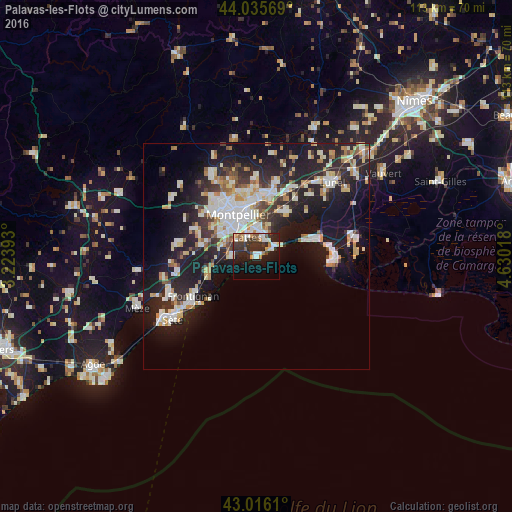
Analysis of Palavas-les-Flots night lights 2016
Square area 10x10 km:
 5.4%
5.4%90-99
5.87%80-89
1.59%70-79
3.02%60-69
3.17%50-59
4.29%40-49
1.75%30-39
8.89%20-29
15.08%10-19
21.9%0-9
29.05%Square area 50x50 km:
4.25%90-99
4.73%80-89
2.44%70-79
2.17%60-69
2.23%50-59
1.57%40-49
1.63%30-39
2.71%20-29
7.96%10-19
17.91%0-9
52.4%Clear (daylight) street map image can be seen on geolist.org.
Map coordinates:
44° 2' 8.5" North, 3° 13' 26.1" East
43° 31' 41" North, 3° 55' 37.4" East
43° 0' 58" North, 4° 37' 48.6" East
Some cities around Palavas-les-Flots sort by population:
• Montpellier
10.1 km =6.3 mi,  336°
336°
• Mauguio
11.9 km =7.4 mi,  32°
32°
• Castelnau-le-Lez
11.9 km =7.4 mi,  349°
349°
• Lattes
4.7 km =2.9 mi, 337°
• Saint-Jean-de-Védas
9.8 km =6.1 mi,  304°
304°
• Pérols
4.4 km =2.7 mi, 27°
• Villeneuve-lès-Maguelone
4.9 km =3 mi,  276°
276°
• Fabrègues
12.4 km =7.7 mi, 281°
2988742 (p: 6,055)
Sources (retrieved 2019-11-25):
» Earth at Night: Flat Maps 2012, 2016