Castelnau-le-Lez night lights from space
Night Light of Castelnau-le-Lez (Occitanie) from space (France) Src. Average luminocity for 10x10km area is 82.003% and for 50x50km: 22.7152%.
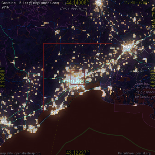
Analysis of Castelnau-le-Lez night lights 2016
Square area 10x10 km:
 35.3%
35.3%90-99
20.76%80-89
8.48%70-79
8.18%60-69
6.21%50-59
8.03%40-49
6.97%30-39
5.91%20-29
0.15%10-19
0%0-9
0%Square area 50x50 km:
4.3%90-99
4.88%80-89
2.59%70-79
2.27%60-69
2.36%50-59
1.71%40-49
1.83%30-39
2.91%20-29
8.06%10-19
18.44%0-9
50.65%Clear (daylight) street map image can be seen on geolist.org.
Map coordinates:
44° 8' 24.3" North, 3° 11' 48.8" East
43° 37' 60" North, 3° 54' 0" East
43° 7' 20.2" North, 4° 36' 11.3" East
Some cities around Castelnau-le-Lez sort by population:
• Montpellier
3.1 km =1.9 mi,  216°
216°
• Lattes
7.3 km =4.5 mi,  177°
177°
• Le Crès
3.6 km =2.2 mi,  62°
62°
• Juvignac
7.5 km =4.7 mi,  253°
253°
• Vendargues
6.3 km =3.9 mi, 63°
• Clapiers
2.9 km =1.8 mi,  342°
342°
• Saint-Clément-de-Rivière
7.7 km =4.8 mi,  316°
316°
• Jacou
3.3 km =2.1 mi,  17°
17°
3028337 (p: 18,011)
Sources (retrieved 2019-11-25):
» Earth at Night: Flat Maps 2012, 2016