Mauguio night lights from space
Night Light of Mauguio (Occitanie) from space (France) Src. Average luminocity for 10x10km area is 42.9424% and for 50x50km: 23.7964%.
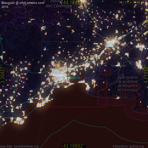
Analysis of Mauguio night lights 2016
Square area 10x10 km:
 6.21%
6.21%90-99
9.09%80-89
6.06%70-79
4.85%60-69
3.48%50-59
3.03%40-49
7.27%30-39
9.24%20-29
19.39%10-19
30.15%0-9
1.21%Square area 50x50 km:
4.28%90-99
5.04%80-89
2.89%70-79
2.45%60-69
2.46%50-59
1.81%40-49
1.96%30-39
3.01%20-29
9.36%10-19
19.07%0-9
47.67%Clear (daylight) street map image can be seen on geolist.org.
Map coordinates:
44° 7' 29.9" North, 3° 18' 15.4" East
43° 37' 5.2" North, 4° 0' 26.6" East
43° 6' 24.9" North, 4° 42' 37.9" East
Some cities around Mauguio sort by population:
• Castelnau-le-Lez
8.8 km =5.5 mi,  281°
281°
• Pérols
7.6 km =4.7 mi,  216°
216°
• Le Crès
6.4 km =4 mi,  301°
301°
• La Grande-Motte
8.4 km =5.2 mi,  133°
133°
• Baillargues
5 km =3.1 mi,  8°
8°
• Vendargues
5.4 km =3.4 mi,  326°
326°
• Castries
7.1 km =4.4 mi,  343°
343°
• Jacou
9 km =5.6 mi, 302°
2995121 (p: 18,320)
Sources (retrieved 2019-11-25):
» Earth at Night: Flat Maps 2012, 2016