Villeneuve-lès-Maguelone night lights from space
Night Light of Villeneuve-lès-Maguelone (Occitanie) from space (France) Src. Average luminocity for 10x10km area is 37.981% and for 50x50km: 21.0796%.
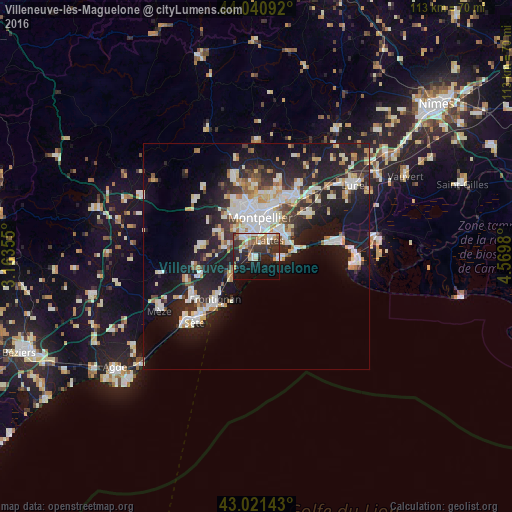
Analysis of Villeneuve-lès-Maguelone night lights 2016
Square area 10x10 km:
 5.71%
5.71%90-99
6.67%80-89
3.65%70-79
4.6%60-69
4.44%50-59
6.03%40-49
2.22%30-39
11.43%20-29
16.35%10-19
23.49%0-9
15.4%Square area 50x50 km:
4.14%90-99
4.67%80-89
2.2%70-79
2.06%60-69
2.18%50-59
1.38%40-49
1.63%30-39
2.69%20-29
7.54%10-19
17.38%0-9
54.14%Clear (daylight) street map image can be seen on geolist.org.
Map coordinates:
44° 2' 27.3" North, 3° 9' 48.8" East
43° 31' 60" North, 3° 52' 0" East
43° 1' 17.1" North, 4° 34' 11.3" East
Some cities around Villeneuve-lès-Maguelone sort by population:
• Montpellier
8.7 km =5.4 mi,  5°
5°
• Lattes
4.9 km =3 mi,  38°
38°
• Saint-Jean-de-Védas
5.9 km =3.7 mi,  326°
326°
• Pérols
7.6 km =4.7 mi,  64°
64°
• Fabrègues
7.5 km =4.7 mi,  284°
284°
• Pignan
10.3 km =6.4 mi,  303°
303°
• Juvignac
10 km =6.2 mi, 333°
• Palavas-les-Flots
4.9 km =3 mi,  96°
96°
2968536 (p: 8,343)
Sources (retrieved 2019-11-25):
» Earth at Night: Flat Maps 2012, 2016