Périgny night lights from space
Night Light of Périgny (Nouvelle-Aquitaine) from space (France) Src. Average luminocity for 10x10km area is 44.4616% and for 50x50km: 6.3021%.
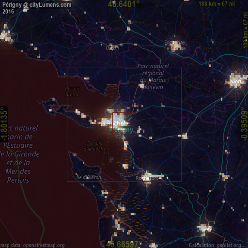
Analysis of Périgny night lights 2016
Square area 10x10 km:
 10.94%
90-99
14.77%80-89
5.11%70-79
2.7%60-69
2.56%50-59
1.99%40-49
2.41%30-39
4.55%20-29
14.63%10-19
20.17%0-9
20.17%Square area 50x50 km:
1.08%90-99
1.48%80-89
0.56%70-79
0.69%60-69
0.49%50-59
0.57%40-49
0.56%30-39
0.6%20-29
1.48%10-19
4.29%0-9
88.19%Clear (daylight) street map image can be seen on geolist.org.
Map coordinates:
46° 38' 24.4" North, 1° 48' 4.9" West
46° 9' 18.7" North, 1° 5' 53.6" West
45° 39' 57.5" North, 0° 23' 42.3" West
Some cities around Périgny sort by population:
• La Rochelle
4.2 km =2.6 mi,  287°
287°
• Rochefort
25.8 km =16 mi,  156°
156°
• Aytré
2.5 km =1.6 mi,  210°
210°
• Lagord
5.6 km =3.5 mi,  310°
310°
• Châtelaillon-Plage
9.3 km =5.8 mi,  175°
175°
• Nieul-sur-Mer
7.6 km =4.7 mi,  317°
317°
• Surgères
27.2 km =16.9 mi,  101°
101°
• Dompierre-sur-Mer
4.5 km =2.8 mi,  36°
36°
2987976 (p: 6,460)
Sources (retrieved 2019-11-25):
» Earth at Night: Flat Maps 2012, 2016