La Rochelle night lights from space
Night Light of La Rochelle (Nouvelle-Aquitaine) from space (France) Src. Average luminocity for 10x10km area is 60.8523% and for 50x50km: 6.1135%.
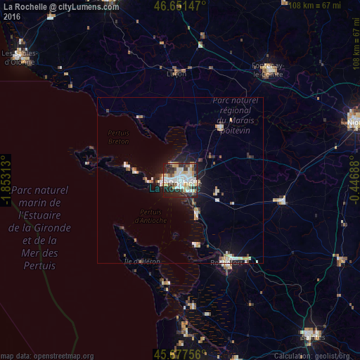
Analysis of La Rochelle night lights 2016
Square area 10x10 km:
 15.48%
90-99
19.46%80-89
6.53%70-79
5.97%60-69
4.69%50-59
3.41%40-49
4.83%30-39
7.95%20-29
21.45%10-19
10.23%0-9
0%Square area 50x50 km:
1.04%90-99
1.45%80-89
0.53%70-79
0.67%60-69
0.46%50-59
0.56%40-49
0.56%30-39
0.62%20-29
1.48%10-19
4.15%0-9
88.47%Clear (daylight) street map image can be seen on geolist.org.
Map coordinates:
46° 39' 5.3" North, 1° 51' 11.3" West
46° 10' 0" North, 1° 9' 0" West
45° 40' 39.2" North, 0° 26' 48.8" West
Some cities around La Rochelle sort by population:
• Rochefort
28.7 km =17.8 mi,  150°
150°
• Aytré
4.4 km =2.7 mi,  141°
141°
• Lagord
2.4 km =1.5 mi,  353°
353°
• Saint-Pierre-d’Oléron
27.5 km =17.1 mi,  206°
206°
• Périgny
4.2 km =2.6 mi,  107°
107°
• Châtelaillon-Plage
11.5 km =7.1 mi,  156°
156°
• Nieul-sur-Mer
4.5 km =2.8 mi, 345°
• Dompierre-sur-Mer
7.1 km =4.4 mi,  70°
70°
3006787 (p: 76,810)
Sources (retrieved 2019-11-25):
» NASA, Earths city lights 1995
» NASA city lights 2003
» Earth at Night: Flat Maps 2012, 2016